IMAGES TAKEN NEAR TO
Belton Park Drive, CATTERICK GARRISON, DL9 4SL
Introduction
This page details the photographs taken nearby to Belton Park Drive, DL9 4SL by members of the Geograph project.
The Geograph project started in 2005 with the aim of publishing, organising and preserving representative images for every square kilometre of Great Britain, Ireland and the Isle of Man.

There are currently over 7.5m images from over14,400 individuals and you can help contribute to the project by visiting https://www.geograph.org.uk
Image Map
Images are licensed for reuse under creativecommons.org/licenses/by-sa/2.0
Notes
- Clicking on the map will re-center to the selected point.
- The higher the marker number, the further away the image location is from the centre of the postcode.
Image Listing (14 Images Found)
Images are licensed for reuse under creativecommons.org/licenses/by-sa/2.0
Image
Details
Distance
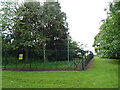
1

Entrance to Rosedale Care Home from Catterick Road
Image: © Roger Templeman
Taken: 28 May 2016
0.12 miles
2
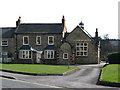
Hipswell Kindergarten
Located in the old school facing the village green.
Image: © David Rogers
Taken: 11 Mar 2009
0.18 miles
3
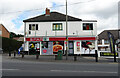
Post Office and shop on Catterick Road, Catterick Garrison
Image: © JThomas
Taken: 24 Jul 2020
0.18 miles
4
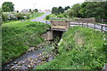
Bridge taking Byng Road of Colburn Beck
Fairly new stone parapets
Image: © Roger Templeman
Taken: 28 May 2016
0.18 miles
7
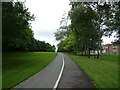
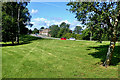
Dual use path, Linear Park, Catterick Garrison
Image: © JThomas
Taken: 24 Jul 2020
0.20 miles
8

Hipswell Postbox
VR Box adjacent to the village green.
Image: © David Rogers
Taken: 7 Jul 2009
0.22 miles
9
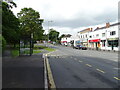
Bus stop and shelter on Catterick Road, Catterick Garrison
The A6136.
Image: © JThomas
Taken: 24 Jul 2020
0.22 miles
10
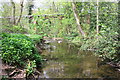
Cottages Beck looking towards overhead pipeline
Image: © Roger Templeman
Taken: 12 May 2016
0.23 miles