IMAGES TAKEN NEAR TO
Catterick Road, CATTERICK GARRISON, DL9 4RT
Introduction
This page details the photographs taken nearby to Catterick Road, DL9 4RT by members of the Geograph project.
The Geograph project started in 2005 with the aim of publishing, organising and preserving representative images for every square kilometre of Great Britain, Ireland and the Isle of Man.

There are currently over 7.5m images from over14,400 individuals and you can help contribute to the project by visiting https://www.geograph.org.uk
Image Map
Images are licensed for reuse under creativecommons.org/licenses/by-sa/2.0
Notes
- Clicking on the map will re-center to the selected point.
- The higher the marker number, the further away the image location is from the centre of the postcode.
Image Listing (6 Images Found)
Images are licensed for reuse under creativecommons.org/licenses/by-sa/2.0
Image
Details
Distance
1
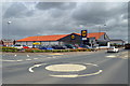
Lidl, Walkerville
On the site of the former Walkerville Hotel
Image: © Tony Simms
Taken: 12 May 2015
0.04 miles
5
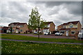
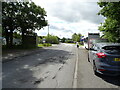
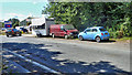
Brough with St Giles
This small hamlet sprang up in the late 20th century and is named after the civil parish which formerly comprised Brough Hall and a few farms and cottages. The residents unsuccessfully petitioned to change the postcode to the supposedly more desirable Richmond DL10 from the allocated Catterick Garrison DL9.
Image: © Tony Simms
Taken: 13 May 2015
0.15 miles
6

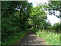
Horse Park Wood
View from Sour Bridge looking west.
Image: © Matthew Hatton
Taken: 28 Oct 2009
0.25 miles