IMAGES TAKEN NEAR TO
St. Giles Close, CATTERICK GARRISON, DL9 4NU
Introduction
This page details the photographs taken nearby to St. Giles Close, DL9 4NU by members of the Geograph project.
The Geograph project started in 2005 with the aim of publishing, organising and preserving representative images for every square kilometre of Great Britain, Ireland and the Isle of Man.

There are currently over 7.5m images from over14,400 individuals and you can help contribute to the project by visiting https://www.geograph.org.uk
Image Map
Images are licensed for reuse under creativecommons.org/licenses/by-sa/2.0
Notes
- Clicking on the map will re-center to the selected point.
- The higher the marker number, the further away the image location is from the centre of the postcode.
Image Listing (10 Images Found)
Images are licensed for reuse under creativecommons.org/licenses/by-sa/2.0
Image
Details
Distance
1
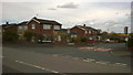
St Cuthberts Close, Colburn
Late sixties/early seventies housing. These are on the northernmost edge of Colburn town.
Image: © Tony Simms
Taken: 11 May 2015
0.06 miles
2
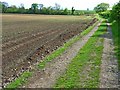
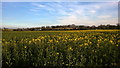
Coast to Coast walk, east of Colburn
The Coast to Coast walk was devised by Wainwright in 1973. Although it has not received official recognition as a National Trail, it has become hugely popular amongst walkers. http://www.ramblers.org.uk/info/paths/coasttocoast.html Here it drops down to cross the northern end of the Vale of York before gaining the Cleveland Hills.
Image: © Oliver Dixon
Taken: 18 May 2006
0.15 miles
3
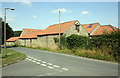
Colburn Waste Water Treatment Works
The sewage works on the north side of Colburn.
Image: © Frank Glover
Taken: 8 Apr 2007
0.20 miles
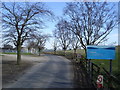
4
Coast to Coast walk, old Colburn village
The Coast to Coast Walk was devised by Wainwright in 1973, and despite not having official recognition as a National Trail, is hugely popular amongst walkers. http://www.ramblers.org.uk/info/paths/coasttocoast.html At this point, the walk coming from Richmond briefly follows the tarmac through old Colburn village. The white house in the foreground is Kildavin which, although it doesn't look like it, was originally a chapel. Much improved and extended, it was occupied by my son in the 1990s. Since then it has been even further improved and extended.
Image: © Oliver Dixon
Taken: 18 May 2006
0.20 miles
5
Colburn Water Treatment Works
The Yorkshire Water treatment plant photographed from the Coast to Coast footpath/bridleway
Image: © Tony Simms
Taken: 20 Apr 2015
0.21 miles
6
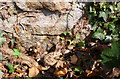
Benchmark behind ivy on corner of barn conversion, Colburn Lane
Ordnance Survey cut mark benchmark described on the Bench Mark Database at http://www.bench-marks.org.uk/bm78122
Image: © Roger Templeman
Taken: 16 Aug 2016
0.23 miles
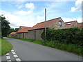
8
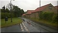
Barn conversion beside Colburn Lane
There is an OS benchmarkImage on the near (ivy covered) corner, road face, of the building, by the telephone pole
Image: © Roger Templeman
Taken: 16 Aug 2016
0.24 miles
10

Colburn Waste Water Treatment Works
As advertised: The Sewage Works at Colburn.
Image: © Frank Glover
Taken: 8 Apr 2007
0.25 miles