IMAGES TAKEN NEAR TO
Catterick Road, CATTERICK GARRISON, DL9 4LR
Introduction
This page details the photographs taken nearby to Catterick Road, DL9 4LR by members of the Geograph project.
The Geograph project started in 2005 with the aim of publishing, organising and preserving representative images for every square kilometre of Great Britain, Ireland and the Isle of Man.

There are currently over 7.5m images from over14,400 individuals and you can help contribute to the project by visiting https://www.geograph.org.uk
Image Map
Images are licensed for reuse under creativecommons.org/licenses/by-sa/2.0
Notes
- Clicking on the map will re-center to the selected point.
- The higher the marker number, the further away the image location is from the centre of the postcode.
Image Listing (9 Images Found)
Images are licensed for reuse under creativecommons.org/licenses/by-sa/2.0
Image
Details
Distance
1

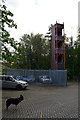
Colburn fire station
Colburn fire station, Catterick Road, Colburn, North Yorkshire
Image: © Kevin Hale
Taken: 3 Aug 2010
0.12 miles
2
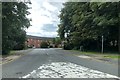
Entrance to Hipswell Court Development
Entrance to Horseshoe Close into Hipswell Court Development off Catterick Road.
Image: © David Robinson
Taken: 21 Jul 2019
0.13 miles
6
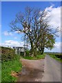
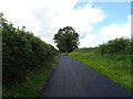
Back lane to Old Colburn
Spot the telecoms mast amongst the trees. This is a very quiet road indeed, as there is a deep ford just as you enter Old Colburn village. Consequently all traffic for the village takes the other road in.
Image: © Oliver Dixon
Taken: 18 May 2006
0.23 miles

8
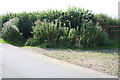
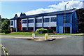
Gateway from the minor road running north from Hipswell towards Colburn
There is an OS benchmark Image on a stone at the base of the wall hidden in the hedge to the left of the gate, where there is a hole through the roadside vegetation
Image: © Roger Templeman
Taken: 16 Aug 2016
0.24 miles
9
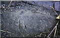
Benchmark on rock at base of wall beside Hipswell to Colburn road
Ordnance Survey rivet benchmark described on the Bench Mark Database at http://www.bench-marks.org.uk/bm78056
Image: © Roger Templeman
Taken: 16 Aug 2016
0.25 miles