IMAGES TAKEN NEAR TO
Lingfield Close, CATTERICK GARRISON, DL9 4GL
Introduction
This page details the photographs taken nearby to Lingfield Close, DL9 4GL by members of the Geograph project.
The Geograph project started in 2005 with the aim of publishing, organising and preserving representative images for every square kilometre of Great Britain, Ireland and the Isle of Man.

There are currently over 7.5m images from over14,400 individuals and you can help contribute to the project by visiting https://www.geograph.org.uk
Image Map
Images are licensed for reuse under creativecommons.org/licenses/by-sa/2.0
Notes
- Clicking on the map will re-center to the selected point.
- The higher the marker number, the further away the image location is from the centre of the postcode.
Image Listing (5 Images Found)
Images are licensed for reuse under creativecommons.org/licenses/by-sa/2.0
Image
Details
Distance
1
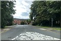
Entrance to Hipswell Court Development
Entrance to Horseshoe Close into Hipswell Court Development off Catterick Road.
Image: © David Robinson
Taken: 21 Jul 2019
0.10 miles
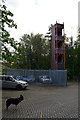
3

Colburn fire station
Colburn fire station, Catterick Road, Colburn, North Yorkshire
Image: © Kevin Hale
Taken: 3 Aug 2010
0.14 miles