IMAGES TAKEN NEAR TO
Elm Close, CATTERICK GARRISON, DL9 4BA
Introduction
This page details the photographs taken nearby to Elm Close, DL9 4BA by members of the Geograph project.
The Geograph project started in 2005 with the aim of publishing, organising and preserving representative images for every square kilometre of Great Britain, Ireland and the Isle of Man.

There are currently over 7.5m images from over14,400 individuals and you can help contribute to the project by visiting https://www.geograph.org.uk
Image Map
Images are licensed for reuse under creativecommons.org/licenses/by-sa/2.0
Notes
- Clicking on the map will re-center to the selected point.
- The higher the marker number, the further away the image location is from the centre of the postcode.
Image Listing (15 Images Found)
Images are licensed for reuse under creativecommons.org/licenses/by-sa/2.0
Image
Details
Distance
1
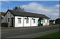
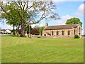
Hipswell Village Hall
Facing The Green on Hipswell Road.
Image: © David Rogers
Taken: 11 Mar 2009
0.02 miles
2

Hipswell Postbox
VR Box adjacent to the village green.
Image: © David Rogers
Taken: 7 Jul 2009
0.02 miles
3
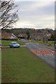
Hipswell
Approaching the village green.
Image: © Mick Garratt
Taken: 15 Dec 2010
0.05 miles
4
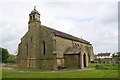
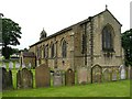
St John's, Hipswell
There's the remnants of a proper village here with a stone built parish church of 1811, a village green, and a 16th century hall not far away, but mostly Hipswell is swamped by the anonymous housing developments that surround the military establishments of Catterick Garrison.
Image: © Gordon Hatton
Taken: 5 Jan 2022
0.06 miles
5
St John's Church
There is an OS benchmark Image on the near angle, left hand face, of the belfry jut
Image: © Roger Templeman
Taken: 28 May 2016
0.06 miles
6
Hipswell Parish Church
St John The Evangelist is situated at the top end of The Green in Hipswell.
Image: © David Rogers
Taken: 7 Jul 2009
0.06 miles
7
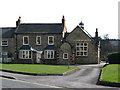
Hipswell Kindergarten
Located in the old school facing the village green.
Image: © David Rogers
Taken: 11 Mar 2009
0.06 miles
8
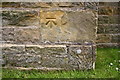
Benchmark on St John's Church
Ordnance Survey cut mark benchmark described on the Bench Mark Database at http://www.bench-marks.org.uk/bm75904
Image: © Roger Templeman
Taken: 28 May 2016
0.07 miles
9
St John the Evangelist Church, Hipswell
Built in 1811. Hipswell is one of the villages which has been almost swallowed up by the growth of Catterick Garrison.
Image: © Oliver Dixon
Taken: 18 May 2006
0.08 miles
10
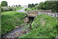
Bridge taking Byng Road of Colburn Beck
Fairly new stone parapets
Image: © Roger Templeman
Taken: 28 May 2016
0.12 miles