IMAGES TAKEN NEAR TO
Airedale Road, CATTERICK GARRISON, DL9 3JU
Introduction
This page details the photographs taken nearby to Airedale Road, DL9 3JU by members of the Geograph project.
The Geograph project started in 2005 with the aim of publishing, organising and preserving representative images for every square kilometre of Great Britain, Ireland and the Isle of Man.

There are currently over 7.5m images from over14,400 individuals and you can help contribute to the project by visiting https://www.geograph.org.uk
Image Map
Images are licensed for reuse under creativecommons.org/licenses/by-sa/2.0
Notes
- Clicking on the map will re-center to the selected point.
- The higher the marker number, the further away the image location is from the centre of the postcode.
Image Listing (19 Images Found)
Images are licensed for reuse under creativecommons.org/licenses/by-sa/2.0
Image
Details
Distance
1
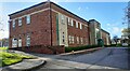
Catterick Courts Centre on south side of Leyburn Road
Ordnance Survey documents indicate that a benchmark levelled at 146.999m above Newlyn Datum was verified in 1955 on a building on this site. The present building was opened in April 2007 so it appears safe to assume the building there in 1955 has been demolished
Image: © Roger Templeman
Taken: 11 Nov 2022
0.14 miles
2
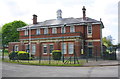
Building 45, Leyburn Road
There is an OS benchmark Image at the right hand corner of the former fire station.
Image: © Roger Templeman
Taken: 16 May 2016
0.14 miles
3
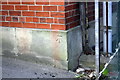
Benchmark on Building 45
Ordnance Survey cut mark benchmark described on the Bench Mark Database at http://www.bench-marks.org.uk/bm75548
Image: © Roger Templeman
Taken: 16 May 2016
0.15 miles
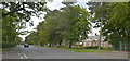
5
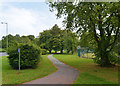
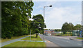
Cycle path linking Leyburn Road and Scotton Road, Catterick Garrison
Image: © habiloid
Taken: 10 Aug 2020
0.16 miles
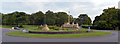
6

Catterick Armistice Memorial
This Armistice memorial includes a stone train and statues of 3 military personnel, including Lord Baden Powell. It was unveiled in December 2018 watched by the people of Catterick and David Evans, a 100 year-old Dunkirk veteran from Leyburn. From 1914 to its closure in 1969 the railway was extremely important in moving troops and material.
Image: © Rebecca A Wills
Taken: 7 Nov 2021
0.18 miles
7
Camp Centre, Catterick Garrison
This roundabout is at the junction of Richmond Road (A6136), Catterick Road (A6136), Scotton Road and Leyburn Road.
Image: © habiloid
Taken: 10 Aug 2020
0.18 miles
8
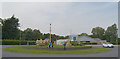
Camp Centre, Catterick Garrison
This roundabout is at the junction of Richmond Road (A6136), Catterick Road (A6136), Scotton Road and Leyburn Road.
Image: © habiloid
Taken: 10 Aug 2020
0.18 miles
9
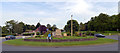
Camp Centre, Catterick Garrison
This roundabout is at the junction of Richmond Road (A6136), Catterick Road (A6136), Scotton Road and Leyburn Road.
Image: © habiloid
Taken: 10 Aug 2020
0.18 miles
10
Military Building, Scotton Road, Catterick Garrison
Image: © habiloid
Taken: 10 Aug 2020
0.18 miles