IMAGES TAKEN NEAR TO
Lincoln Close, DL9 3ES
Introduction
This page details the photographs taken nearby to Lincoln Close, DL9 3ES by members of the Geograph project.
The Geograph project started in 2005 with the aim of publishing, organising and preserving representative images for every square kilometre of Great Britain, Ireland and the Isle of Man.

There are currently over 7.5m images from over14,400 individuals and you can help contribute to the project by visiting https://www.geograph.org.uk
Image Map
Images are licensed for reuse under creativecommons.org/licenses/by-sa/2.0
Notes
- Clicking on the map will re-center to the selected point.
- The higher the marker number, the further away the image location is from the centre of the postcode.
Image Listing (21 Images Found)
Images are licensed for reuse under creativecommons.org/licenses/by-sa/2.0
Image
Details
Distance
1
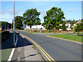
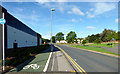
Gough Road
The entrance to the leisure centre is on the right.
Image: © Thomas Nugent
Taken: 29 Aug 2016
0.15 miles
3
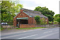
Building 92, Catterick Golf Club, Leyburn Road
There is an OS benchmark Image on the near corner, left hand face, of the building (behind the brick wall)
Image: © Roger Templeman
Taken: 23 May 2016
0.16 miles
4
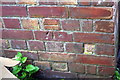
Benchmark on Building 92, Leyburn Road
Ordnance Survey cut mark benchmark described on the Bench Mark Database at http://www.bench-marks.org.uk/bm75550
Image: © Roger Templeman
Taken: 23 May 2016
0.16 miles
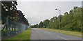
5
Gough Road
Shared footpath and cycle lane at the B&M Home Store.
Image: © Thomas Nugent
Taken: 29 Aug 2016
0.17 miles
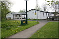
6
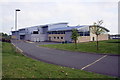
The back of the Library and Leisure Centre
Image: © Roger Templeman
Taken: 12 May 2016
0.18 miles
8

B&M Home Store at Catterick Garrison
On Gough Road, beside Tesco.
Image: © Thomas Nugent
Taken: 29 Aug 2016
0.19 miles
9
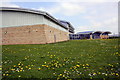
Library and Leisure Centre
A good crop of dandelions!
Image: © Roger Templeman
Taken: 12 May 2016
0.20 miles
10
Site of tank loading dock beside former railway on north side of Leyburn Road
Ordnance Survey records indicate that a benchmark levelled at 152.748m above Newlyn Datum was verified in 1955 on the loading dock previously at this location
Image: © Roger Templeman
Taken: 15 Dec 2022
0.21 miles