IMAGES TAKEN NEAR TO
Plumer Road, CATTERICK GARRISON, DL9 3DQ
Introduction
This page details the photographs taken nearby to Plumer Road, DL9 3DQ by members of the Geograph project.
The Geograph project started in 2005 with the aim of publishing, organising and preserving representative images for every square kilometre of Great Britain, Ireland and the Isle of Man.

There are currently over 7.5m images from over14,400 individuals and you can help contribute to the project by visiting https://www.geograph.org.uk
Image Map
Images are licensed for reuse under creativecommons.org/licenses/by-sa/2.0
Notes
- Clicking on the map will re-center to the selected point.
- The higher the marker number, the further away the image location is from the centre of the postcode.
Image Listing (5 Images Found)
Images are licensed for reuse under creativecommons.org/licenses/by-sa/2.0
Image
Details
Distance
1
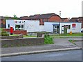
Waitwith Post Office and Plumer Road Fish Shop
Small corner shop development in the western part of Catterick Garrison.
Image: © Oliver Dixon
Taken: 18 May 2006
0.06 miles
2
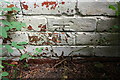
Benchmark on building on Hipswell Road West
Ordnance Survey cut mark benchmark described on the Bench Mark Database at http://www.bench-marks.org.uk/bm76836
Image: © Roger Templeman
Taken: 27 Jun 2016
0.14 miles
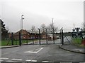
3
Boarded up building on Hipswell Road West
Part (at least) of the building was occupied by White Rose Bowling Club. There is an OS benchmark Image on the face of the building behind the tree in the middle of the image
Image: © Roger Templeman
Taken: 27 Jun 2016
0.14 miles
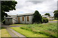
5
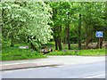
Woodland Walk, Plumer Road
A little bit of the country in the middle of Catterick Garrison
Image: © Oliver Dixon
Taken: 18 May 2006
0.24 miles