IMAGES TAKEN NEAR TO
Plumer Road, CATTERICK GARRISON, DL9 3AG
Introduction
This page details the photographs taken nearby to Plumer Road, DL9 3AG by members of the Geograph project.
The Geograph project started in 2005 with the aim of publishing, organising and preserving representative images for every square kilometre of Great Britain, Ireland and the Isle of Man.

There are currently over 7.5m images from over14,400 individuals and you can help contribute to the project by visiting https://www.geograph.org.uk
Image Map
Images are licensed for reuse under creativecommons.org/licenses/by-sa/2.0
Notes
- Clicking on the map will re-center to the selected point.
- The higher the marker number, the further away the image location is from the centre of the postcode.
Image Listing (5 Images Found)
Images are licensed for reuse under creativecommons.org/licenses/by-sa/2.0
Image
Details
Distance
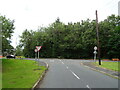
2
Electricity substations at Plumer Road / Bourlon Road junction
Image: © Roger Templeman
Taken: 16 May 2016
0.05 miles
4

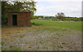
Derelict Building north edge of Catterick Garrison
This appears to have been changing/toilet facilities and is presumably MOD related in view of its position.
Image: © Tony Simms
Taken: 19 May 2015
0.18 miles