IMAGES TAKEN NEAR TO
Bellerby, LEYBURN, DL8 5QP
Introduction
This page details the photographs taken nearby to DL8 5QP by members of the Geograph project.
The Geograph project started in 2005 with the aim of publishing, organising and preserving representative images for every square kilometre of Great Britain, Ireland and the Isle of Man.

There are currently over 7.5m images from over14,400 individuals and you can help contribute to the project by visiting https://www.geograph.org.uk
Image Map (Loading...)


Getting Data...Please wait
Leaflet Map data © OpenStreetMap
Images are licensed for reuse under creativecommons.org/licenses/by-sa/2.0
Notes
- Clicking on the map will re-center to the selected point.
- The higher the marker number, the further away the image location is from the centre of the postcode.
Image Listing (43 Images Found)
Images are licensed for reuse under creativecommons.org/licenses/by-sa/2.0
Image
Details
Distance
1
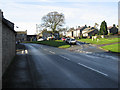
Stream on Moor Road
Section of the water channel that runs through the village of Bellerby.
Image: © Chris Heaton
Taken: 8 Jul 2016
0.01 miles
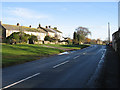
4
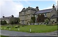
Beside The Green
A house on Bellerby Village Green.
Image: © Roger Gilbertson
Taken: 19 Nov 2006
0.02 miles
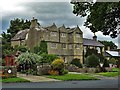
6
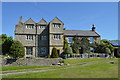
Manor (?) House on the green, Bellerby
Large manorial type property with later farmstead type building attached. Disappointingly since the first Geograph for this square, the end building now sports solar panels.
Image: © Tony Simms
Taken: 10 Jun 2015
0.03 miles
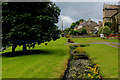
7
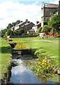
The green at Bellerby
The stream here is the mill race for the former corn mill. In the background is the projecting porch bay of Bellerby Manor House which dates from the early 17thC.
Image: © Gordon Hatton
Taken: 8 Aug 2015
0.03 miles
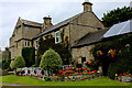
8
The Old Hall and Village Green, Bellerby
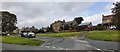
The village is at the end of Wensleydale, nestled in a dip amongst low hills and standing at 205 metres above sea level with an open south-easterly aspect. Above the village are gently rising fields and moorlands to the north and west.
http://www.bellerbyvillage.co.uk/
Image: © Russel Wills
Taken: 26 Apr 2016
0.03 miles
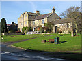
9
Old Hall, Bellerby
17th Century Grade II Listed Building, with fine mullioned windows - on Moor Road.
Image: © Neil Theasby
Taken: 14 Aug 2017
0.03 miles
10
Old Hall, Bellerby
17th Century Grade II Listed Building, with fine mullioned windows - on Moor Road, in the village of Bellerby
Image: © Chris Heaton
Taken: 8 Jul 2016
0.04 miles