IMAGES TAKEN NEAR TO
Spennithorne, LEYBURN, DL8 5PU
Introduction
This page details the photographs taken nearby to DL8 5PU by members of the Geograph project.
The Geograph project started in 2005 with the aim of publishing, organising and preserving representative images for every square kilometre of Great Britain, Ireland and the Isle of Man.

There are currently over 7.5m images from over14,400 individuals and you can help contribute to the project by visiting https://www.geograph.org.uk
Image Map (Loading...)


Getting Data...Please wait
Leaflet Map data © OpenStreetMap
Images are licensed for reuse under creativecommons.org/licenses/by-sa/2.0
Notes
- Clicking on the map will re-center to the selected point.
- The higher the marker number, the further away the image location is from the centre of the postcode.
Image Listing (7 Images Found)
Images are licensed for reuse under creativecommons.org/licenses/by-sa/2.0
Image
Details
Distance
1
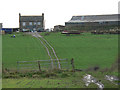
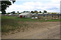
Eastfield House Farm
As seen from an adjoining square. There is no public access to SE1588.
Image: © Roger Gilbertson
Taken: 19 Nov 2006
0.03 miles
2
Baled And Bagged
Plastic covered bales at Eastfield House Farm.
Image: © Roger Gilbertson
Taken: 19 Nov 2006
0.03 miles
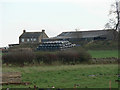
3
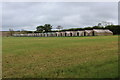
Poultry Sheds
These appear to be sheds associated with low density/intensity poultry/egg production.
Image: © Tony Simms
Taken: 20 May 2015
0.22 miles
4
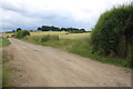
Access track to Eastfield Game Farm from West Moor Lane
There is an OS benchmark Image on the stone gatepost at the right hand side of the image
Image: © Roger Templeman
Taken: 1 Aug 2016
0.23 miles
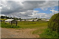
5
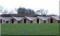
Row of Huts, Eastfield House Farm
These huts appear unoccupied and unused, with every door open.
Research suggests these structures are used in the rearing of grouse and other game birds.
Image: © Chris Heaton
Taken: 24 May 2020
0.23 miles
6
Grouse rearing huts beside access track to Eastfield Game Farm
Image: © Roger Templeman
Taken: 1 Aug 2016
0.24 miles
7
Agricultural accommodation
Residents not identified!
Image: © Russel Wills
Taken: 17 Jan 2020
0.25 miles