IMAGES TAKEN NEAR TO
Finghall, LEYBURN, DL8 5NE
Introduction
This page details the photographs taken nearby to DL8 5NE by members of the Geograph project.
The Geograph project started in 2005 with the aim of publishing, organising and preserving representative images for every square kilometre of Great Britain, Ireland and the Isle of Man.

There are currently over 7.5m images from over14,400 individuals and you can help contribute to the project by visiting https://www.geograph.org.uk
Image Map
Images are licensed for reuse under creativecommons.org/licenses/by-sa/2.0
Notes
- Clicking on the map will re-center to the selected point.
- The higher the marker number, the further away the image location is from the centre of the postcode.
Image Listing (7 Images Found)
Images are licensed for reuse under creativecommons.org/licenses/by-sa/2.0
Image
Details
Distance
1
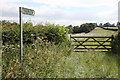
Footpath leading to Ruswick Manor farm
Image: © Andrew Whale
Taken: 10 Jul 2010
0.11 miles
2
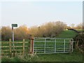
Footpath near Finghall
The point at which footpath number 20.66/14/1 leaves a minor road in the general direction of Newton le Willows. The '20' refers to Richmondshire and '66' is the parish, which is Finghall.
Image: © Gordon Hatton
Taken: 25 Mar 2020
0.11 miles
3
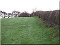
Fields To Newton-le-Willows
Ostensibly a Public Footpath but with little evidence of recently having been used.
Image: © Roger Gilbertson
Taken: 19 Nov 2006
0.13 miles
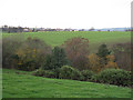
4
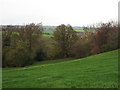
Sloping To The Trees
A view from the Public Footpath between Finghall and Newton-le-Willows.
Image: © Roger Gilbertson
Taken: 19 Nov 2006
0.13 miles
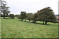
5
Looking Towards Finghall Village
From the Public Footpath to Newton-le-Willows.
Image: © Roger Gilbertson
Taken: 19 Nov 2006
0.13 miles
6
On Foot From Newton-le-Willows.
Along a Public Footpath towards Finghall.
Image: © Roger Gilbertson
Taken: 19 Nov 2006
0.13 miles
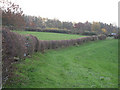
7
A row of hawthorn trees beside footpath
Image: © Roger Templeman
Taken: 21 Sep 2014
0.21 miles