IMAGES TAKEN NEAR TO
Hauxwell, LEYBURN, DL8 5LP
Introduction
This page details the photographs taken nearby to Hauxwell, DL8 5LP by members of the Geograph project.
The Geograph project started in 2005 with the aim of publishing, organising and preserving representative images for every square kilometre of Great Britain, Ireland and the Isle of Man.

There are currently over 7.5m images from over14,400 individuals and you can help contribute to the project by visiting https://www.geograph.org.uk
Image Map (Loading...)


Getting Data...Please wait
Leaflet Map data © OpenStreetMap
Images are licensed for reuse under creativecommons.org/licenses/by-sa/2.0
Notes
- Clicking on the map will re-center to the selected point.
- The higher the marker number, the further away the image location is from the centre of the postcode.
Image Listing (51 Images Found)
Images are licensed for reuse under creativecommons.org/licenses/by-sa/2.0
Image
Details
Distance
1
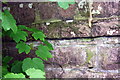
Benchmark on back of bridge parapet at 'The Mill'
Ordnance Survey pivot benchmark described on the Bench Mark Database at http://www.bench-marks.org.uk/bm75750
Image: © Roger Templeman
Taken: 22 May 2016
0.02 miles
2
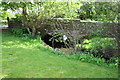
Garriston Beck at 'The Mill'
There is an OS benchmark Image on a ledge on the back of the bridge above the left hand bank of the beck
Image: © Roger Templeman
Taken: 22 May 2016
0.02 miles
3
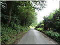
Downhill from East Hauxwell
Towards the Garriston Beck.
Image: © JThomas
Taken: 1 Aug 2020
0.03 miles
4
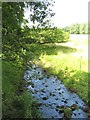
Garriston Beck
Looking upstream from the bridge at West Hauxwell. Garriston Beck runs along the northern side of Lower Wensleydale, but its waters are destined to join the Swale rather than the Ure.
Image: © Gordon Hatton
Taken: 8 Aug 2015
0.05 miles
5

Graveyard at St.Oswald's, East Hauxwell
A very quiet place indeed.
Image: © Matthew Hatton
Taken: 22 Aug 2010
0.09 miles
6
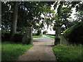
An entrance to Hauxwell Hall
The rear view of the entrance gates.
Image: © Ian S
Taken: 26 Aug 2012
0.09 miles
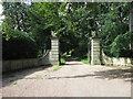
8

Gateway to Hauxwell Hall
The gateway piers, gates and railings here are all grade 2 listed, the piers being early 19th century in date and each surmounted by a stone griffin.
Image: © Gordon Hatton
Taken: 8 Jan 2019
0.11 miles
9

Scrolled Carving
Fancy carving on this 19thC grave stone.
Image: © Matthew Hatton
Taken: 22 Aug 2010
0.12 miles
10

St. Oswald's Church
A very ancient church; the oldest in Richmondshire.
Image: © Matthew Hatton
Taken: 22 Aug 2010
0.12 miles