IMAGES TAKEN NEAR TO
Woodside, LEYBURN, DL8 5DX
Introduction
This page details the photographs taken nearby to Woodside, DL8 5DX by members of the Geograph project.
The Geograph project started in 2005 with the aim of publishing, organising and preserving representative images for every square kilometre of Great Britain, Ireland and the Isle of Man.

There are currently over 7.5m images from over14,400 individuals and you can help contribute to the project by visiting https://www.geograph.org.uk
Image Map
Images are licensed for reuse under creativecommons.org/licenses/by-sa/2.0
Notes
- Clicking on the map will re-center to the selected point.
- The higher the marker number, the further away the image location is from the centre of the postcode.
Image Listing (136 Images Found)
Images are licensed for reuse under creativecommons.org/licenses/by-sa/2.0
Image
Details
Distance
1
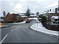
Looking south east down Woodside, Leyburn
This image is taken from the junction with the A6108.
Image: © C P Smith
Taken: 26 Dec 2010
0.05 miles
3

The Wensleydale School, Leyburn
This is the main secondary school for the town of Leyburn and surrounding area.
Image: © C P Smith
Taken: 26 Dec 2010
0.08 miles
4
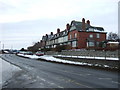
Houses on Richmond Road, Leyburn
Several of the front gardens look as if they offer a challenging opportunity to the enthusiast.
Image: © C P Smith
Taken: 26 Dec 2010
0.09 miles
5
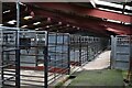
Leyburn Auction Mart
Empty pens at Leyburn Market.
Image: © Robert Struthers
Taken: 30 Jun 2023
0.11 miles
6
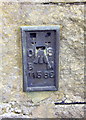
Benchmark on 'Prospect Villa'
Ordnance Survey flush bracket (serial number 11586) benchmark on side of the house described on the Bench Mark Database at http://www.bench-marks.org.uk/bm11876
Image: © Roger Templeman
Taken: 30 Aug 2012
0.13 miles
7
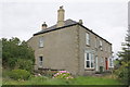
Prospect Villa, Richmond Road (A6108)
There is an OS flush bracket Image visible on the facing corner of the house
Image: © Roger Templeman
Taken: 30 Aug 2012
0.13 miles
8
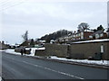
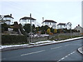
Looking south west over Thornborough Crescent.
This image was taken from Richmond Road (the A6108). Thornborough Crescent presumably takes its name from nearby Thornborough Hall.
Image: © C P Smith
Taken: 26 Dec 2010
0.14 miles
9
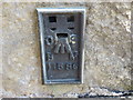
Ordnance Survey Flush Bracket 11586
This can be found on the wall of a private house in Richmond Road.
For more detail see : http://www.bench-marks.org.uk/log?bm_key=11876
Image: © Peter Wood
Taken: 17 Jul 2013
0.14 miles
10
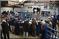
Leyburn Auction Mart
A scene unchanged for generations; farmers buy and sell livestock at public auction, with the auctioneer keeping up a rapid update on bid price while looking out for the smallest of gestures that indicate a new bid.
Image: © Robert Struthers
Taken: 30 Jun 2023
0.14 miles