IMAGES TAKEN NEAR TO
LEYBURN, DL8 5AZ
Introduction
This page details the photographs taken nearby to DL8 5AZ by members of the Geograph project.
The Geograph project started in 2005 with the aim of publishing, organising and preserving representative images for every square kilometre of Great Britain, Ireland and the Isle of Man.

There are currently over 7.5m images from over14,400 individuals and you can help contribute to the project by visiting https://www.geograph.org.uk
Image Map (Loading...)


Getting Data...Please wait
Leaflet Map data © OpenStreetMap
Images are licensed for reuse under creativecommons.org/licenses/by-sa/2.0
Notes
- Clicking on the map will re-center to the selected point.
- The higher the marker number, the further away the image location is from the centre of the postcode.
Image Listing (244 Images Found)
Images are licensed for reuse under creativecommons.org/licenses/by-sa/2.0
Image
Details
Distance
1
![Leyburn buildings [4]](https://s2.geograph.org.uk/geophotos/07/33/08/7330878_04234e55_120x120.jpg)
Leyburn buildings [4]
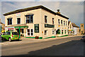
Clyde House, Market Place, was built in the early 19th century. Constructed of rendered rubble stone under a stone slate roof. Now used as a bed and breakfast establishment. Listed, grade II, with details at: https://historicengland.org.uk/listing/the-list/list-entry/1130903
Leyburn is a market town in the Richmondshire district of North Yorkshire, some 16 miles west of Northallerton and 7½ miles southwest of Richmond. The town was mentioned in the Domesday Book and its growth as a major hub is linked to the decline in fortunes of nearby Wensley, which had prominence as the only market town in Wensleydale until being devastated by the plague in 1563. Leyburn is a gateway town to the Yorkshire Dales National Park and relies heavily on tourism.
Image: © Michael Dibb
Taken: 24 Jun 2022
0.03 miles
4
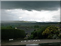
Wensleydale Weather
The clouds are not taking any notice.
Image: © David Rogers
Taken: 7 Aug 2010
0.04 miles
6
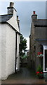
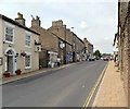
Old Chapel Alley
Leading from Railway Street to Old Chapel.
Image: © David Rogers
Taken: 7 Aug 2010
0.04 miles
7
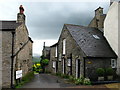
Off Market Place, Leyburn
Leading to Dales View Holiday Homes.
Image: © David Rogers
Taken: 7 Aug 2010
0.04 miles
8
![Leyburn buildings [1]](https://s0.geograph.org.uk/geophotos/02/45/41/2454144_d6cc1eef_120x120.jpg)
Leyburn buildings [1]
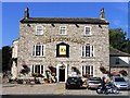
The Picturehouse was originally the Elite. Closed in 2007 when the owners retired, it re-opened in 2008 with local volunteers. Now, sadly, it seems to be closed again and up for sale.
Leyburn is a market town in the Richmondshire district of North Yorkshire, some 16 miles west of Northallerton and 7½ miles southwest of Richmond. The town was mentioned in the Domesday Book and its growth as a major hub is linked to the decline in fortunes of nearby Wensley, which had prominence as the only market town in Wensleydale until being devastated by the plague in 1563. Leyburn is a gateway town to the Yorkshire Dales National Park and relies heavily on tourism.
Image: © Michael Dibb
Taken: 21 May 2011
0.05 miles
9
The Picture House
The former Elite Cinema in Leyburn.
Image: © David Rogers
Taken: 7 Aug 2010
0.05 miles