IMAGES TAKEN NEAR TO
East Witton, LEYBURN, DL8 4SX
Introduction
This page details the photographs taken nearby to DL8 4SX by members of the Geograph project.
The Geograph project started in 2005 with the aim of publishing, organising and preserving representative images for every square kilometre of Great Britain, Ireland and the Isle of Man.

There are currently over 7.5m images from over14,400 individuals and you can help contribute to the project by visiting https://www.geograph.org.uk
Image Map
Images are licensed for reuse under creativecommons.org/licenses/by-sa/2.0
Notes
- Clicking on the map will re-center to the selected point.
- The higher the marker number, the further away the image location is from the centre of the postcode.
Image Listing (17 Images Found)
Images are licensed for reuse under creativecommons.org/licenses/by-sa/2.0
Image
Details
Distance
1
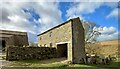
Sowden Beck Farm
Sowden Beck Road (by this point just a track as indicated on the map, and no longer having a tarmac surface as it does on the climb from East Witton) leads to Sowden Beck Farm, via a ford. Fortunately for pedestrians, there is also a small footbridge. The byway containues through the farm and up fields to reach the open fell where it meets a good track running left and right, but continues as a rather lower quality track across the moor, where, at the next parish boundary, it is downgraded to just a bridleway.
Image: © Andy Waddington
Taken: 14 Mar 2022
0.01 miles
2
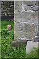
Benchmark on building at Sowden Beck Farm
Ordnance Survey cut mark benchmark described on the Bench Mark Database at http://www.bench-marks.org.uk/bm45124
Image: © Roger Templeman
Taken: 30 Aug 2012
0.01 miles
3
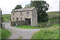
Sowden Beck Farm
There is an OS benchmark Image on the front side corner of the building
Image: © Roger Templeman
Taken: 30 Aug 2012
0.01 miles
4
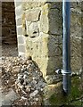
East Witton, Sowden Beck Farm
The benchmark is cut into the east face of an outbuilding to the farm.
Image: © Mel Towler
Taken: 5 Mar 2022
0.01 miles
5
East Witton, Sowden Beck Farm
There is a benchmark cut into the east face of an outbuilding to the farm. The mark is to the left of the drainpipe.
Image: © Mel Towler
Taken: 5 Mar 2022
0.01 miles
6
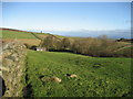
Field south of Sowden Beck Farm
The farm itself is concealed tightly in the valley of the beck, and only one of the outer buildings is visible from this part of the field
Image: © Chris Heaton
Taken: 10 Jan 2007
0.03 miles
8
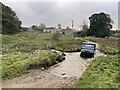
Sowden Beck Farm Ford
This ford is found in the entrance to Sowden Beck Farm. A video of the ford can be viewed at:
https://youtu.be/W6ypeLI_6G4
https://youtu.be/cOTPek701OY
Image: © John Walton
Taken: 18 Oct 2021
0.05 miles
9
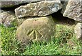
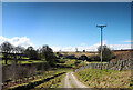
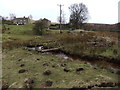
East Witton, farm track
The rivet and arrowhead are cut into a stone in the drystone wall on the west side of the track.
Image: © Mel Towler
Taken: 9 Apr 2022
0.06 miles
10
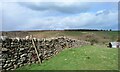
East Witton, farm track
There is a rivet and arrowhead cut into a stone in the drystone wall on the west side of the track. The outbuildings of Sowden Beck Farm are in the background.
Image: © Mel Towler
Taken: 9 Apr 2022
0.06 miles