IMAGES TAKEN NEAR TO
Caldbergh, LEYBURN, DL8 4RP
Introduction
This page details the photographs taken nearby to Caldbergh, DL8 4RP by members of the Geograph project.
The Geograph project started in 2005 with the aim of publishing, organising and preserving representative images for every square kilometre of Great Britain, Ireland and the Isle of Man.

There are currently over 7.5m images from over14,400 individuals and you can help contribute to the project by visiting https://www.geograph.org.uk
Image Map
Images are licensed for reuse under creativecommons.org/licenses/by-sa/2.0
Notes
- Clicking on the map will re-center to the selected point.
- The higher the marker number, the further away the image location is from the centre of the postcode.
Image Listing (5 Images Found)
Images are licensed for reuse under creativecommons.org/licenses/by-sa/2.0
Image
Details
Distance
2
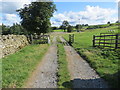
Track and cattle grid at Carldbergh
Looking north-eastward.
Image: © Peter Wood
Taken: 24 Aug 2014
0.20 miles
3
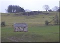
Small field barn
Under a limestone crag below Ashes.
Image: © Russel Wills
Taken: 16 Jan 2020
0.23 miles
5
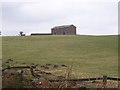
Stone Laithe, near Caldbergh
Lonely barn on a wind swept pasture, high on the southern flanks of Coverdale. I was walking from Braithwaite Hall towards the hamlet of Caldbergh
Image: © Chris Heaton
Taken: 22 Feb 2006
0.25 miles