IMAGES TAKEN NEAR TO
Coverham, Middleham, LEYBURN, DL8 4RN
Introduction
This page details the photographs taken nearby to DL8 4RN by members of the Geograph project.
The Geograph project started in 2005 with the aim of publishing, organising and preserving representative images for every square kilometre of Great Britain, Ireland and the Isle of Man.

There are currently over 7.5m images from over14,400 individuals and you can help contribute to the project by visiting https://www.geograph.org.uk
Image Map (Loading...)


Getting Data...Please wait
Leaflet Map data © OpenStreetMap
Images are licensed for reuse under creativecommons.org/licenses/by-sa/2.0
Notes
- Clicking on the map will re-center to the selected point.
- The higher the marker number, the further away the image location is from the centre of the postcode.
Image Listing (48 Images Found)
Images are licensed for reuse under creativecommons.org/licenses/by-sa/2.0
Image
Details
Distance
1
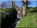
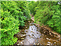
Waterfall feeding the River Cover . Note footpath to the right
Image: © Joe Regan
Taken: 23 Apr 2003
0.01 miles
2
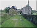
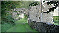
Coverham Abbey Gatehouse
Gatehouse to the west of Coverham Abbey.
Image: © BC
Taken: 21 Aug 2011
0.02 miles
4

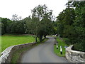
Coverham Bridge
Coverham Bridge over the River Cover in winter
Image: © Anthony Harrison
Taken: 5 Feb 2006
0.04 miles
6
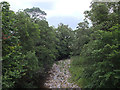
River Cover at Coverham
View downstream from Coverham Bridge.
Image: © David Dixon
Taken: 5 Jul 2021
0.04 miles
7
Abbey Gatehouse
With ruins of Coverham Abbey visible through the arch
Image: © Kevin Waterhouse
Taken: 26 Aug 2017
0.04 miles
8
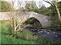
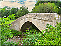
Coverham Bridge, south-west of Middleham
Coverham Bridge is a narrow medieval bridge dating from the 15th or 16th centuries. This attractive bridge carries a minor road across the River Cover, a tributary of the River Ure, and is a Grade II* listed building. https://www.britishlistedbuildings.co.uk/101130893-coverham-bridge-coverham-with-agglethorpe#.WeNk5zGWw5s
Image: © G Laird
Taken: 12 Oct 2017
0.04 miles
10
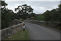
River Cover, Coverham Bridge
Bridge over the River Cover. Built in the 15th/16th century. Grade II* listed building (List Entry Number: 1130893 https://historicengland.org.uk/listing/the-list/list-entry/1130893 Historic England).
Image: © David Dixon
Taken: 5 Jul 2021
0.04 miles