IMAGES TAKEN NEAR TO
East Witton Road, LEYBURN, DL8 4PT
Introduction
This page details the photographs taken nearby to East Witton Road, DL8 4PT by members of the Geograph project.
The Geograph project started in 2005 with the aim of publishing, organising and preserving representative images for every square kilometre of Great Britain, Ireland and the Isle of Man.

There are currently over 7.5m images from over14,400 individuals and you can help contribute to the project by visiting https://www.geograph.org.uk
Image Map
Images are licensed for reuse under creativecommons.org/licenses/by-sa/2.0
Notes
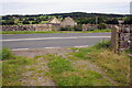
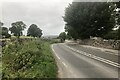
- Clicking on the map will re-center to the selected point.
- The higher the marker number, the further away the image location is from the centre of the postcode.
Image Listing (139 Images Found)
Images are licensed for reuse under creativecommons.org/licenses/by-sa/2.0
Image
Details
Distance
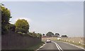
2
View across A6108 east of Middleham
See http://www.bench-marks.org.uk/bm44855 for details of missing gatepost at far side of road
Image: © Roger Templeman
Taken: 31 Aug 2012
0.06 miles
4
![Middleham Castle [9]](https://s1.geograph.org.uk/geophotos/07/33/95/7339569_f8ab06c4_120x120.jpg)
Middleham Castle [9]
The view east from the top of the keep.
Best known as one of the childhood homes of Richard III, Middleham Castle is a ruined castle in Middleham in Wensleydale, North Yorkshire. It was built in rubble stone and ashlar, building work commencing in 1190 with additions and alterations until the 15th century. The castle was built to defend the road from Richmond to Skipton. The castle is a compact, massive structure, and though ruinous, most of the walls are intact. A simple rectangle in plan, the castle consists of a massive Norman keep surrounded by a later curtain wall, to which were then added extensive, palatial residential ranges. The castle fell into disuse and disrepair during the 17th century, and the stones of the castle became a public quarry. Now in the care of English Heritage. Listed, grade I with details at: https://historicengland.org.uk/listing/the-list/list-entry/1318543 A Scheduled Ancient Monument with details at: https://historicengland.org.uk/listing/the-list/list-entry/1010629
Image: © Michael Dibb
Taken: 26 Jun 2022
0.12 miles
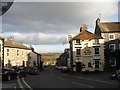
6
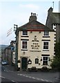
The Black Bull Middleham
One of several pubs still existing in this tiny town, where plenty of thirsty stable lads live.
Image: © Gordon Hatton
Taken: 3 Nov 2008
0.15 miles
7
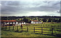
Stables at Middleham, North Yorkshire
Image: © nick macneill
Taken: 12 Aug 1999
0.15 miles
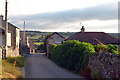
9
Road junction, Middleham
The minor road from Wensley joins the A6108 near the Black Bull. For a view of the sign Image
Image: © Maigheach-gheal
Taken: 4 Oct 2010
0.16 miles
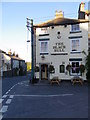
10
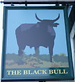
Sign for the Black Bull
The colour black is a very common colour as far as pub names are concerned occurring in at least fifty different names.
It has been suggested that some 'black' names came about when the Gin Act of 1736 came into force, causing tavern owners to drape their signs in black velvet or add 'black' to the pub name.
Perhaps in view of this colour's association with mourning and other rather dreary states of mind, it is surprising that so many names make use of it.
Image: © Maigheach-gheal
Taken: 4 Oct 2010
0.16 miles