IMAGES TAKEN NEAR TO
West Witton, LEYBURN, DL8 4NB
Introduction
This page details the photographs taken nearby to DL8 4NB by members of the Geograph project.
The Geograph project started in 2005 with the aim of publishing, organising and preserving representative images for every square kilometre of Great Britain, Ireland and the Isle of Man.

There are currently over 7.5m images from over14,400 individuals and you can help contribute to the project by visiting https://www.geograph.org.uk
Image Map (Loading...)


Getting Data...Please wait
Leaflet Map data © OpenStreetMap
Images are licensed for reuse under creativecommons.org/licenses/by-sa/2.0
Notes
- Clicking on the map will re-center to the selected point.
- The higher the marker number, the further away the image location is from the centre of the postcode.
Image Listing (4 Images Found)
Images are licensed for reuse under creativecommons.org/licenses/by-sa/2.0
Image
Details
Distance
1
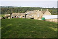
Farm at Low Wanlass
The tup seems to be considering his options regarding the intruder in his domain
Image: © Roger Templeman
Taken: 12 Sep 2014
0.02 miles
2
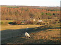
View to Low Wanlass
A view taken from Flats Lane with the well wooded Bolton Park in the background beyond the invisible River Ure.
Image: © Gordon Hatton
Taken: 7 Dec 2022
0.04 miles
3
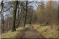
Track in West Wood
Delightful mixed and managed woods on the Bolton Estate, a track ascending high above the banks of the River Ure.
Image: © Chris Heaton
Taken: 3 Mar 2016
0.24 miles
4
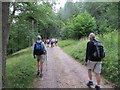
Track Through West Wood
With party of walkers heading north-west.
Image: © Peter Wood
Taken: 21 Aug 2013
0.24 miles