IMAGES TAKEN NEAR TO
West Witton, LEYBURN, DL8 4NA
Introduction
This page details the photographs taken nearby to DL8 4NA by members of the Geograph project.
The Geograph project started in 2005 with the aim of publishing, organising and preserving representative images for every square kilometre of Great Britain, Ireland and the Isle of Man.

There are currently over 7.5m images from over14,400 individuals and you can help contribute to the project by visiting https://www.geograph.org.uk
Image Map (Loading...)


Getting Data...Please wait
Leaflet Map data © OpenStreetMap
Images are licensed for reuse under creativecommons.org/licenses/by-sa/2.0
Notes
- Clicking on the map will re-center to the selected point.
- The higher the marker number, the further away the image location is from the centre of the postcode.
Image Listing (12 Images Found)
Images are licensed for reuse under creativecommons.org/licenses/by-sa/2.0
Image
Details
Distance
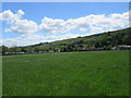
1

Chantry Caravan Park
On the hillside above West Witton, but well hidden amongst trees
Image: © Chris Heaton
Taken: 24 May 2006
0.04 miles
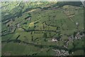
2
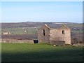
Barn near High Lane
Roofless stone barn in pastureland near High Lane above West Witton. The view across the dale is to the houses at Preston under Scar on the far side.
Image: © Gordon Hatton
Taken: 13 Jan 2012
0.15 miles
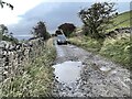
3
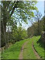
Langthwaite Lane
The eastern end of this grassy lane above West Witton village.
Image: © Gordon Hatton
Taken: 30 Apr 2024
0.15 miles
4
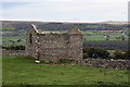
Barn north of High Lane
There is an OS benchmark Image on the near corner, left hand face, of the barn
Image: © Roger Templeman
Taken: 26 Sep 2011
0.15 miles
5
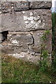
Benchmark on barn off High Lane
Ordnance Survey cut mark benchmark described on the Bench Mark Database at http://www.bench-marks.org.uk/bm39489
Image: © Roger Templeman
Taken: 12 Sep 2014
0.15 miles
8
High Lane Ford
This is the third of four fords on High Lane, a byway above West Witton.
Image: © John Walton
Taken: 18 Oct 2021
0.24 miles
9
Benchmark on Langthwaite Barn
Ordnance Survey cut mark benchmark described on the Bench Mark Database at http://www.bench-marks.org.uk/bm38516
Image: © Roger Templeman
Taken: 28 Jun 2011
0.25 miles
10
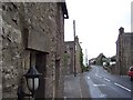
West Witton (West)
Long narrow village spills onto two squares. The A684 Leyburn/Hawes Road forms the main street through this community
Image: © Chris Heaton
Taken: 23 May 2006
0.25 miles