IMAGES TAKEN NEAR TO
Low Lane, LEYBURN, DL8 4HU
Introduction
This page details the photographs taken nearby to Low Lane, DL8 4HU by members of the Geograph project.
The Geograph project started in 2005 with the aim of publishing, organising and preserving representative images for every square kilometre of Great Britain, Ireland and the Isle of Man.

There are currently over 7.5m images from over14,400 individuals and you can help contribute to the project by visiting https://www.geograph.org.uk
Image Map (Loading...)


Getting Data...Please wait
Leaflet Map data © OpenStreetMap
Images are licensed for reuse under creativecommons.org/licenses/by-sa/2.0
Notes
- Clicking on the map will re-center to the selected point.
- The higher the marker number, the further away the image location is from the centre of the postcode.
Image Listing (215 Images Found)
Images are licensed for reuse under creativecommons.org/licenses/by-sa/2.0
Image
Details
Distance
1
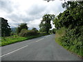
Houses on the north side of Low Lane, Wensley
At the eastern edge of the village.
Image: © Christine Johnstone
Taken: 24 Sep 2016
0.01 miles
2
Nature Reserve: Leyburn Old Glebe Field
Image: © Roger Smith
Taken: 13 May 2008
0.03 miles
3
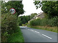
Speed limit, Low Lane, Wensley
Entering the village from the east.
Image: © Christine Johnstone
Taken: 24 Sep 2016
0.03 miles
5
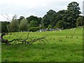
Fallen tree at the eastern edge of Wensley
In a sheep pasture on the north side of Low Lane.
Image: © Christine Johnstone
Taken: 24 Sep 2016
0.05 miles
6
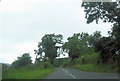
Farmland at Ellershaw, Wensley
On the eastern edge of the village, and the north bank of the River Ure.
Image: © Christine Johnstone
Taken: 24 Sep 2016
0.05 miles
7
Protected saplings at the eastern edge of Wensley
In a sheep pasture on the north side of Low Lane.
Image: © Christine Johnstone
Taken: 24 Sep 2016
0.06 miles
8
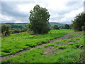
![A circular walk from Leyburn via Wensley village [57]](https://s1.geograph.org.uk/geophotos/07/32/91/7329149_bd698518_120x120.jpg)
A circular walk from Leyburn via Wensley village [57]
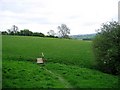
The path heads towards Leyburn. This section is well signed.
From Leyburn the route runs west along the ridge of Leyburn Shawl before descending to Tullis Cote and, after crossing the railway, heading southeast toward the village of Wensley. After passing through Wensley the route is northeast across fields and, after recrossing the railway, returning to the starting point. About 5½ miles.
Image: © Michael Dibb
Taken: 24 Jun 2022
0.08 miles
9
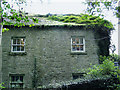
The candlemaker's cottage at Wensley
Apart from housing the business of making decorative candles, this cottage is remarkable for the plant growth on its roof.
Image: © Anthony Harrison
Taken: 19 Oct 2006
0.08 miles
10
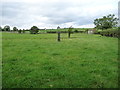
![A circular walk from Leyburn via Wensley village [58]](https://s2.geograph.org.uk/geophotos/07/32/91/7329150_5a17ab66_120x120.jpg)
A circular walk from Leyburn via Wensley village [58]
It is pleasing to see that easy access through the electric fence has been provided. This is not always the case.
From Leyburn the route runs west along the ridge of Leyburn Shawl before descending to Tullis Cote and, after crossing the railway, heading southeast toward the village of Wensley. After passing through Wensley the route is northeast across fields and, after recrossing the railway, returning to the starting point. About 5½ miles.
Image: © Michael Dibb
Taken: 24 Jun 2022
0.09 miles