IMAGES TAKEN NEAR TO
Church Close, LEYBURN, DL8 4HF
Introduction
This page details the photographs taken nearby to Church Close, DL8 4HF by members of the Geograph project.
The Geograph project started in 2005 with the aim of publishing, organising and preserving representative images for every square kilometre of Great Britain, Ireland and the Isle of Man.

There are currently over 7.5m images from over14,400 individuals and you can help contribute to the project by visiting https://www.geograph.org.uk
Image Map
Images are licensed for reuse under creativecommons.org/licenses/by-sa/2.0
Notes
- Clicking on the map will re-center to the selected point.
- The higher the marker number, the further away the image location is from the centre of the postcode.
Image Listing (79 Images Found)
Images are licensed for reuse under creativecommons.org/licenses/by-sa/2.0
Image
Details
Distance
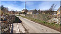
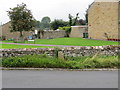
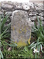
3
Road junction at Yoredale Cottages
Against the wall is a stone (of unknown use) Image
Image: © Roger Templeman
Taken: 24 Jun 2011
0.05 miles
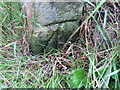
4
Benchmarked stone beside wall at Yoredale Cottages
The Ordnance Survey cut mark benchmark is described on the Bench Mark Database at http://www.bench-marks.org.uk/bm38381
Image: © Roger Templeman
Taken: 24 Jun 2011
0.05 miles
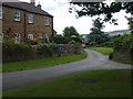
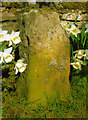
5
Boundary Stone at Cross Roads in Redmire
Viewed from the south-east.
Image: © Peter Wood
Taken: 21 Aug 2013
0.05 miles
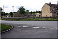
6
Ordnance Survey Cut Mark
This mark can be found on a boundary stone at the cross-roads.
For more detail see : http://www.bench-marks.org.uk/log?bm_key=38381
Image: © Peter Wood
Taken: 21 Aug 2013
0.05 miles
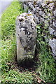
7
Old Milestone by Mill Lane, Redmire
Carved stone post by the UC road, in parish of REDMIRE (RICHMONDSHIRE District), crossroads South end of village, by low wall where 'main' road turned the corner, on Northwest side of road. Richmond LH stone, erected by the Richmond & Lancaster (Eastern District) turnpike trust in the 18th century.
Inscription once read:-
(11)
Carved bench mark recorded.
Milestone Society National ID: YN_LARC45.
Image: © C Minto
Taken: 7 Apr 2007
0.05 miles
8
Footpath to Redmire
The gate Image allows walkers to use the footpath that runs through this paddock to the village of Redmire.
Image: © Maigheach-gheal
Taken: 4 Oct 2010
0.05 miles
9
Old milestone
On the unclasified road north of the River Ure at the south end of Redmire near Yoredale Cottages. This stone which shows very old damage may have been inscribed with an 11 (to Richmond) that has been eroded away in its probable 200 year old history.
Image: © Chris Minto
Taken: 8 Apr 2019
0.05 miles
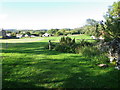
10
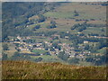
Redmire
Zoomed in view of Redmire from the Penhill trig point.
Image: © T Eyre
Taken: 26 Sep 2021
0.06 miles