IMAGES TAKEN NEAR TO
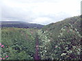
Carperby, LEYBURN, DL8 4DR
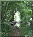
Introduction
This page details the photographs taken nearby to DL8 4DR by members of the Geograph project.
The Geograph project started in 2005 with the aim of publishing, organising and preserving representative images for every square kilometre of Great Britain, Ireland and the Isle of Man.

There are currently over 7.5m images from over14,400 individuals and you can help contribute to the project by visiting https://www.geograph.org.uk
Image Map (Loading...)


Getting Data...Please wait
Leaflet Map data © OpenStreetMap
Images are licensed for reuse under creativecommons.org/licenses/by-sa/2.0
Notes
- Clicking on the map will re-center to the selected point.
- The higher the marker number, the further away the image location is from the centre of the postcode.
Image Listing (16 Images Found)
Images are licensed for reuse under creativecommons.org/licenses/by-sa/2.0
Image
Details
Distance
1
Thoresby Lane
An unclassified road open to motor vehicles! I'm glad I didn't meet a bin lorry!
Image: © David Brown
Taken: 5 Jun 2019
0.15 miles
2
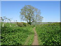
Thoresby Lane
An old route between Aysgarth and Redmire.
Image: © T Eyre
Taken: 20 May 2023
0.16 miles
3
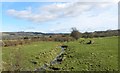
Kendell Beck, Thoresby
Tiny beck which joins the River Ure some 400m downstream from this point.
Image: © Gordon Hatton
Taken: 10 Mar 2012
0.19 miles
5
Beck flowing under Thoresby Lane
The beck runs from Kelder Well and meets the Ure below Slapestone Wath.
Image: © Bill Boaden
Taken: 30 Dec 2014
0.19 miles
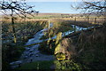
6
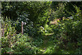
Watery Lane, Thoresby
No prizes for guessing how this bridleway got its name! After a wet August the route is wetter than ever, despite works carried out to divert the water into a side channel. The bridleway leads down to the stepping stones at Slapestone Wath, also likely to be impassable after heavy rain. The helpful 'deep ford' notice on the left refers to Slapestone Wath and not this lane.
Image: © Gordon Hatton
Taken: 24 Aug 2008
0.20 miles
7
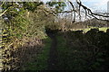
Thoresby Lane
A through route from Low Lane which slowly develops into more of a lane.
Image: © Bill Boaden
Taken: 30 Dec 2014
0.22 miles
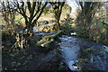
8

High Thoresby Ford
This ford at High Thoresby is found on the track leading down to Slapestone Wath.
Image: © John Walton
Taken: 20 Oct 2021
0.22 miles
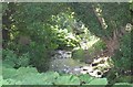
9
Ford and bridge on Watery Lane
I am sure that for much of the year, the beck is less active than this.
Image: © Bill Boaden
Taken: 30 Dec 2014
0.23 miles
10
Footbridge, Watery Lane
Stone clapper bridge on Watery Lane, a route which has always lived up to its name. This side of the bridge the bridleway is dry, but the last 120m or so to the junction with Thoresby Lane involves paddling even during periods of dry weather. Note that this footbridge is not the 'FB' as shown on the OS map.
Image: © Gordon Hatton
Taken: 14 Jul 2021
0.23 miles