IMAGES TAKEN NEAR TO
Aysgarth, LEYBURN, DL8 3ST
Introduction
This page details the photographs taken nearby to DL8 3ST by members of the Geograph project.
The Geograph project started in 2005 with the aim of publishing, organising and preserving representative images for every square kilometre of Great Britain, Ireland and the Isle of Man.

There are currently over 7.5m images from over14,400 individuals and you can help contribute to the project by visiting https://www.geograph.org.uk
Image Map
Images are licensed for reuse under creativecommons.org/licenses/by-sa/2.0
Notes
- Clicking on the map will re-center to the selected point.
- The higher the marker number, the further away the image location is from the centre of the postcode.
Image Listing (81 Images Found)
Images are licensed for reuse under creativecommons.org/licenses/by-sa/2.0
Image
Details
Distance
1
Flattlands, Aysgarth
And yes, I have spelt that correctly!
Image: © David Purchase
Taken: 4 Jun 2018
0.01 miles
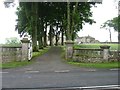
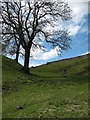
2
Thieves Gill
Thieves Gill is an unusual dry valley that carves its way through the landscape just to the south of Aysgarth village. Most likely it was formed by glacial meltwaters along the edge of the Bishopdale glacier.
Image: © Gordon Hatton
Taken: 6 Mar 2011
0.05 miles
3
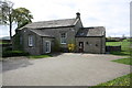
Aysgarth Surgery
There is an OS benchmark Image on the base quoin behind the forsythia bush
Image: © Roger Templeman
Taken: 28 Apr 2019
0.07 miles
4
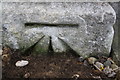
Benchmark on Aysgarth Surgery
Ordnance Survey cut mark benchmark described on the Bench Mark Database at www.bench-marks.org.uk/bm25436
Image: © Roger Templeman
Taken: 28 Apr 2019
0.07 miles
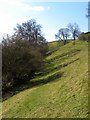
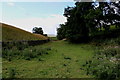
5
Path to Aysgarth
The footpath to Aysgarth climbs past an ash tree out of Thieves Gill on the route from Eshington Bridge.
Image: © Gordon Hatton
Taken: 11 Apr 2009
0.08 miles
7
![Thieves Gill [1]](https://s0.geograph.org.uk/photos/88/31/883116_d967b6ff_120x120.jpg)
Thieves Gill [1]
Thieves Gill is a fascinating little valley which extends from the Aysgarth - Thoralby Road at SE006875 to the Aysgarth - West Burton road at SE016882. It begins like a natural trench along the daleside before dropping down into the dale bottom. Dry throughout [except after heavy rains] it marks the course taken by glacial meltwaters. One possibility is that this was a meltwater channel running along the edge of the Bishopdale glacier, whilst another is that it may have been cut by water running beneath a glacier.
Image: © Gordon Hatton
Taken: 13 Jul 2008
0.14 miles
8
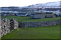
Field and walls at Aysgarth
With snow on the hills beyond.
Image: © David Martin
Taken: 15 Feb 2016
0.15 miles
9
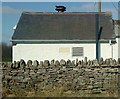
Little White Building
Aysgarth Telephone Exchange on a bright crisp spring day.
Image: © Matthew Hatton
Taken: 6 Mar 2011
0.16 miles
10
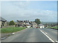
Aysgarth centre
Approaching junction for Aysgarth Falls from eastbound A684
Image: © John Firth
Taken: 14 May 2012
0.17 miles