IMAGES TAKEN NEAR TO
West End, HAWES, DL8 3RT
Introduction
This page details the photographs taken nearby to West End, DL8 3RT by members of the Geograph project.
The Geograph project started in 2005 with the aim of publishing, organising and preserving representative images for every square kilometre of Great Britain, Ireland and the Isle of Man.

There are currently over 7.5m images from over14,400 individuals and you can help contribute to the project by visiting https://www.geograph.org.uk
Image Map
Images are licensed for reuse under creativecommons.org/licenses/by-sa/2.0
Notes
- Clicking on the map will re-center to the selected point.
- The higher the marker number, the further away the image location is from the centre of the postcode.
Image Listing (165 Images Found)
Images are licensed for reuse under creativecommons.org/licenses/by-sa/2.0
Image
Details
Distance
2
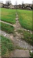
Pennine Way approaching Gayle
After 14 miles of rugged and testing terrain since leaving Horton-in-Ribblesdale, the National Trail finally reaches Gayle and civilisation in Wensleydale
Image: © Chris Heaton
Taken: 3 Jun 2015
0.04 miles
5
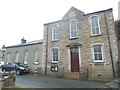
Gayle Methodist Chapel
Situated in Garris DL8 3RS, this Wesleyan chapel was erected in 1833 and altered in 1879. It is one of several churches in the North Yorkshire Dales Methodist Circuit and has Services each Sunday evening at 6.00pm.
Image: © David Hillas
Taken: 7 Oct 2017
0.06 miles
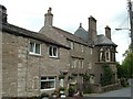
6
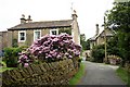
Harker Hill, Gayle
Park House on the left, Rookhurst on the right in background. Rookhurst began as an 18th century farmhouse which was added to in Victorian Gothic style in 1869. It is now a hotel.
Image: © David Pickersgill
Taken: 26 Jun 2009
0.06 miles
7
![Gayle houses [4]](https://s3.geograph.org.uk/geophotos/07/00/75/7007599_1e23615c_120x120.jpg)
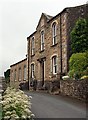
Gayle houses [4]
The front elevation of Park House in Harker Hill. Built in the late 18th or early 19th century. Constructed of coursed rubble stone under a stone slate roof. Another view of the house is at Image Listed, grade II, with details at: https://historicengland.org.uk/listing/the-list/list-entry/1132005
Gayle is a hamlet slightly less than half a mile south of Hawes. Gayle Beck tumbles steeply through the hamlet and formerly fed the water-driven cotton mill. Aysgill Force, a spectacular waterfall, is about one mile upstream.
Image: © Michael Dibb
Taken: 19 Jun 2021
0.06 miles
8
![Gayle houses [3]](https://s1.geograph.org.uk/geophotos/07/00/75/7007597_33cd3f36_120x120.jpg)
Gayle houses [3]
The rear elevation of Park House in Harker Hill. Built in the late 18th or early 19th century. Constructed of coursed rubble stone under a stone slate roof. Another view of the house is at Image Listed, grade II, with details at: https://historicengland.org.uk/listing/the-list/list-entry/1132005
Gayle is a hamlet slightly less than half a mile south of Hawes. Gayle Beck tumbles steeply through the hamlet and formerly fed the water-driven cotton mill. Aysgill Force, a spectacular waterfall, is about one mile upstream.
Image: © Michael Dibb
Taken: 19 Jun 2021
0.06 miles
9
![Gayle buildings [1]](https://s2.geograph.org.uk/geophotos/07/00/84/7008406_b02f9a8d_120x120.jpg)
Gayle buildings [1]
Gayle Methodist church was built as a Wesleyan chapel in 1833 and the schoolroom was added in 1879. Constructed of coursed squared stone with ashlar dressings to the front, rubble stone to the sides, all under a stone slate roof.
Gayle is a hamlet slightly less than half a mile south of Hawes. Gayle Beck tumbles steeply through the hamlet and formerly fed the water-driven cotton mill. Aysgill Force, a spectacular waterfall, is about one mile upstream.
Image: © Michael Dibb
Taken: 19 Jun 2021
0.07 miles
10
Gayle Methodist Church
A surprisingly high proportion of small Wensleydale villages retain active Methodist chapels.
Image: © David Pickersgill
Taken: 26 Jun 2009
0.07 miles