IMAGES TAKEN NEAR TO
Little Ings, HAWES, DL8 3RP
Introduction
This page details the photographs taken nearby to Little Ings, DL8 3RP by members of the Geograph project.
The Geograph project started in 2005 with the aim of publishing, organising and preserving representative images for every square kilometre of Great Britain, Ireland and the Isle of Man.

There are currently over 7.5m images from over14,400 individuals and you can help contribute to the project by visiting https://www.geograph.org.uk
Image Map
Images are licensed for reuse under creativecommons.org/licenses/by-sa/2.0
Notes
- Clicking on the map will re-center to the selected point.
- The higher the marker number, the further away the image location is from the centre of the postcode.
Image Listing (200 Images Found)
Images are licensed for reuse under creativecommons.org/licenses/by-sa/2.0
Image
Details
Distance
1
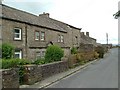
Cottages, Gayle
Looking down towards Hawes
Image: © Paul Shreeve
Taken: 22 Jun 2009
0.03 miles
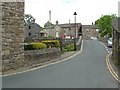
3

The Little White Bus at Gayle Outstation
This photo shows no 2 (AF62 NLY) a 16-seater minibus belonging to The Little White Bus Company parked at Gayle outstation DL8 3RS. The lettering above the side windows indicates that the bus runs a service between Gayle and Garsdale Station via Hawes and Hardraw. It connects with the train service at Garsdale Station on the Settle & Carlisle Railway. At one time, this outstation housed two red buses belonging to United Automobile Services, for use on the service to Leyburn, which The little White Bus does today.
Image: © David Hillas
Taken: 7 Oct 2017
0.04 miles
4
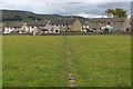
Pennine Way approaching Gayle
After 14 miles of rugged and testing terrain since leaving Horton-in-Ribblesdale, the National Trail finally reaches Gayle and civilisation in Wensleydale
Image: © Chris Heaton
Taken: 3 Jun 2015
0.04 miles
5
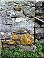
Benchmark on barn at Gayle
Ordnance Survey cut mark benchmark described on the Bench Mark Database at http://www.bench-marks.org.uk/bm24332
Image: © Roger Templeman
Taken: 16 Jul 2010
0.04 miles
6
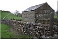
Barn beside the Pennine Way in Gayle
There is an OS benchmark Image on the first corner stone visible above the dry stone wall on the near corner of the barn
Image: © Roger Templeman
Taken: 10 May 2013
0.04 miles
7
![A walk from Hawes to Aysgill Force and back [5]](https://s1.geograph.org.uk/geophotos/07/00/58/7005877_64504d4e_120x120.jpg)
A walk from Hawes to Aysgill Force and back [5]
The path, part of the long distance Pennine Way, enters the village of Gayle.
Starting from the village of Hawes, the walk follows Gayle Beck through the village of Gayle to the spectacular waterfall of Aysgill Force. Then the walk continues to follow the beck upstream to Sleddale Pasture before returning to Gayle via a track on the lower slopes of Swinesett Hill. From Gayle the walk returns to Hawes via Gayle Lane. About 3¾ miles.
Image: © Michael Dibb
Taken: 19 Jun 2021
0.04 miles
8
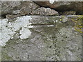
Ordnance Survey Cut Mark
This mark can be found on the wall of a barn in Gayle Lane.
For more detail see : http://www.bench-marks.org.uk/bm24332
Image: © Peter Wood
Taken: 30 Jun 2012
0.05 miles