IMAGES TAKEN NEAR TO
Lowgate, HAWES, DL8 3PE
Introduction
This page details the photographs taken nearby to Lowgate, DL8 3PE by members of the Geograph project.
The Geograph project started in 2005 with the aim of publishing, organising and preserving representative images for every square kilometre of Great Britain, Ireland and the Isle of Man.

There are currently over 7.5m images from over14,400 individuals and you can help contribute to the project by visiting https://www.geograph.org.uk
Image Map
Images are licensed for reuse under creativecommons.org/licenses/by-sa/2.0
Notes
- Clicking on the map will re-center to the selected point.
- The higher the marker number, the further away the image location is from the centre of the postcode.
Image Listing (50 Images Found)
Images are licensed for reuse under creativecommons.org/licenses/by-sa/2.0
Image
Details
Distance
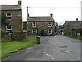
1
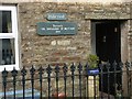
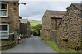
Former village inn, The Shoulder of Mutton.
The Shoulder of Mutton Inn, in Middlegate, was owned around 1800 by William Kilburn and his family but closed before the large quarries began in the 1850's. Now a house, called Hillcrest, it still reflects its original use, with a double privy and a hennery-piggery standing in the back garden.
Image: © brian alderman
Taken: 31 Jan 2009
0.08 miles
2
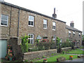
Hillcrest in Burtersett
Was formerly the Shoulder Of Mutton Inn
Image: © John Firth
Taken: 10 Jul 2010
0.08 miles
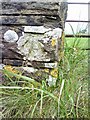
3
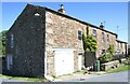
Hillcrest, Burtersett
There is an Ordnance Survey benchmark Image on the left hand side of the house on a base stone in the middle of the face
Image: © Luke Shaw
Taken: 24 May 2019
0.09 miles
4
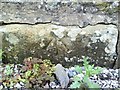
Benchmark in Burtersett
Ordnance Survey pivot benchmark on the side of Hillcrest which was formerly The Shoulder of Mutton Inn. More information on this mark can be found on the Bench Mark Database at http://www.bench-marks.org.uk/bm27802
Image: © Roger Templeman
Taken: 14 Jul 2010
0.09 miles
6
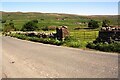
Field gateway on east side of New Lane
There is an Ordnance Survey benchmark Image on the road face of the left hand gateway pier
Image: © Luke Shaw
Taken: 24 May 2019
0.10 miles
8
Benchmark on New Lane wall pier
Ordnance Survey cut mark benchmark on wall pier at gateway on east side of New Lane. For more information on this mark see the Bench Mark Database at http://www.bench-marks.org.uk/bm27613.
Image: © Roger Templeman
Taken: 14 Jul 2010
0.10 miles
10
Burtersett
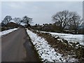
New Lane heading north through the hamlet of Burtersett
Image: © Chris Heaton
Taken: 3 Jun 2015
0.11 miles