IMAGES TAKEN NEAR TO
Main Street, LEYBURN, DL8 3HT
Introduction
This page details the photographs taken nearby to Main Street, DL8 3HT by members of the Geograph project.
The Geograph project started in 2005 with the aim of publishing, organising and preserving representative images for every square kilometre of Great Britain, Ireland and the Isle of Man.

There are currently over 7.5m images from over14,400 individuals and you can help contribute to the project by visiting https://www.geograph.org.uk
Image Map
Images are licensed for reuse under creativecommons.org/licenses/by-sa/2.0
Notes
- Clicking on the map will re-center to the selected point.
- The higher the marker number, the further away the image location is from the centre of the postcode.
Image Listing (191 Images Found)
Images are licensed for reuse under creativecommons.org/licenses/by-sa/2.0
Image
Details
Distance
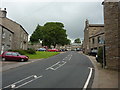
1
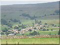
Askrigg
Zoomed view of Askrigg from the south.
Image: © T Eyre
Taken: 11 Sep 2022
0.01 miles
2
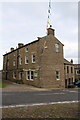
'Holmedale', Bed & Breakfast
There is an OS benchmark Image on the road face of the building below the black metal grill
Image: © Roger Templeman
Taken: 8 Sep 2014
0.02 miles
3
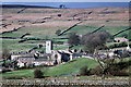
Askrigg in Wensleydale
A view from the south over the Ure, similar to Image] in April 2010, but taken eleven years previously.
Image: © Julian Paren
Taken: Unknown
0.02 miles
5
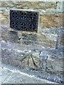
Benchmark on Holmdale B&B
Ordnance Survey pivot benchmark below grill on side of the Holmdale B&B. More information on this mark may be found on the Bench Mark Database at http://www.bench-marks.org.uk/bm27853
Image: © Roger Templeman
Taken: 23 Jul 2010
0.03 miles
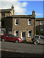
8
![Askrigg houses [1]](https://s3.geograph.org.uk/geophotos/07/31/39/7313995_462b24ae_120x120.jpg)
Askrigg houses [1]
Church View South, is a cottage dated 1687, which has had later alterations. Constructed of coursed rubble stone under a stone slate roof. The central door is in an ashlar quoined moulded surround having a very deep lintel with 2 semicircular niches and recessed panels. Listed, for group value, grade II, with details at: https://historicengland.org.uk/listing/the-list/list-entry/1131190
Askrigg is a small, linear village in Wensleydale in the Yorkshire Dales National Park, some 10 miles west of Leyburn, and 5 miles east of Hawes. Settled since the Iron Age, the name Askrigg is Old Norse - askr (ash tree) and hryggr (ridge), - the ridge where ash trees grew. The village was granted a weekly Market Charter by Elizabeth I in 1587. More recently, the village served as the fictional town of Darrowby in the 1978-1990 BBC TV series ‘All Creatures Great and Small’.
Image: © Michael Dibb
Taken: 22 Jun 2022
0.03 miles
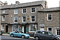
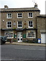
9
House on the Market Place (Church View)
It has a fine carved lintel over the door, dated 1687 see http://www.geograph.org.uk/photo/1586117 . The house was built for one Thomas Foster.
Image: © Alan Murray-Rust
Taken: 9 Nov 2009
0.04 miles
10
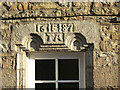
Stone lintel
A close-up of the fine carved lintel of the house on Church View http://www.geograph.org.uk/photo/1586114
Image: © Alan Murray-Rust
Taken: 9 Nov 2009
0.04 miles