IMAGES TAKEN NEAR TO
West End, LEYBURN, DL8 3HN
Introduction
This page details the photographs taken nearby to West End, DL8 3HN by members of the Geograph project.
The Geograph project started in 2005 with the aim of publishing, organising and preserving representative images for every square kilometre of Great Britain, Ireland and the Isle of Man.

There are currently over 7.5m images from over14,400 individuals and you can help contribute to the project by visiting https://www.geograph.org.uk
Image Map
Images are licensed for reuse under creativecommons.org/licenses/by-sa/2.0
Notes
- Clicking on the map will re-center to the selected point.
- The higher the marker number, the further away the image location is from the centre of the postcode.
Image Listing (191 Images Found)
Images are licensed for reuse under creativecommons.org/licenses/by-sa/2.0
Image
Details
Distance
2
![A circular walk around Askrigg [53]](https://s3.geograph.org.uk/geophotos/07/31/20/7312011_a033959f_120x120.jpg)
A circular walk around Askrigg [53]
The path passes through this somewhat overgrown area to end at Main Street.
From Askrigg village, the route goes northwest following Whitfield Gill upstream, passing Mill Gill Force and Whitfield Gill Lower Falls to reach Whitfield Gill Force. Then a return to Whitfield Gill Lower Falls to cross the gill before ascending to Low Straights Lane. The lane is followed eastwards for some distance before a turn south takes a path across fields to return to the starting point. About 3½ miles.
Image: © Michael Dibb
Taken: 22 Jun 2022
0.01 miles
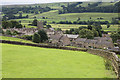
4
![Askrigg houses [5]](https://s2.geograph.org.uk/geophotos/07/31/40/7314018_affa5b88_120x120.jpg)
Askrigg houses [5]
West End House, Main Street, was built in the 17th century or, probably, earlier. Constructed of rubble stone under a stone slate roof. It is 'T' shaped with rear projecting range. Many original and early internal features and fitting remain. Listed, grade II*, with details at: https://historicengland.org.uk/listing/the-list/list-entry/1131195
Askrigg is a small, linear village in Wensleydale in the Yorkshire Dales National Park, some 10 miles west of Leyburn, and 5 miles east of Hawes. Settled since the Iron Age, the name Askrigg is Old Norse - askr (ash tree) and hryggr (ridge), - the ridge where ash trees grew. The village was granted a weekly Market Charter by Elizabeth I in 1587. More recently, the village served as the fictional town of Darrowby in the 1978-1990 BBC TV series ‘All Creatures Great and Small’.
Image: © Michael Dibb
Taken: 22 Jun 2022
0.01 miles
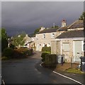
6
![Askrigg houses [4]](https://s3.geograph.org.uk/geophotos/07/31/40/7314015_9c8fb4c5_120x120.jpg)
Askrigg houses [4]
West End Cottage, Main Street, was originally the low end of West End House Image Built in the 17th century with later alterations, constructed of rubble stone under an artificial stone slate roof. The cottage contains what was the through passage behind the main fireplace of West End House. Listed, grade II, with details at: https://historicengland.org.uk/listing/the-list/list-entry/1157475
Askrigg is a small, linear village in Wensleydale in the Yorkshire Dales National Park, some 10 miles west of Leyburn, and 5 miles east of Hawes. Settled since the Iron Age, the name Askrigg is Old Norse - askr (ash tree) and hryggr (ridge), - the ridge where ash trees grew. The village was granted a weekly Market Charter by Elizabeth I in 1587. More recently, the village served as the fictional town of Darrowby in the 1978-1990 BBC TV series ‘All Creatures Great and Small’.
Image: © Michael Dibb
Taken: 22 Jun 2022
0.01 miles
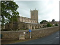
7
St. Oswald's, Askrigg
Church of England parish church.
Image: © philandju
Taken: 10 Sep 2015
0.01 miles
8
![Askrigg houses [6]](https://s1.geograph.org.uk/geophotos/07/31/40/7314021_fe732e82_120x120.jpg)
Askrigg houses [6]
Peninver House, Main Street, was built in the early 19th century. Constructed of squared, coursed, watershot rubble stone under a stone slate roof. Listed, for group value, grade II, with details at: https://historicengland.org.uk/listing/the-list/list-entry/1318438
Askrigg is a small, linear village in Wensleydale in the Yorkshire Dales National Park, some 10 miles west of Leyburn, and 5 miles east of Hawes. Settled since the Iron Age, the name Askrigg is Old Norse - askr (ash tree) and hryggr (ridge), - the ridge where ash trees grew. The village was granted a weekly Market Charter by Elizabeth I in 1587. More recently, the village served as the fictional town of Darrowby in the 1978-1990 BBC TV series ‘All Creatures Great and Small’.
Image: © Michael Dibb
Taken: 22 Jun 2022
0.01 miles
9
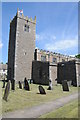
Askrigg church
The tower of Askrigg church.
Image: © Philip Halling
Taken: 8 Jun 2013
0.01 miles
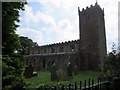
10
![Parish church [2]](https://s2.geograph.org.uk/geophotos/07/31/30/7313034_06aba18e_120x120.jpg)
Parish church [2]
Part of the churchyard.
The Anglican parish church of Saint Oswald was built circa 1446 incorporating some earlier structure. The church was badly restored in 1853. Constructed of rubble stone with lead roofs. The church has a very fine nave ceiling and many fine 18th and early 19th century wall monuments. Listed, grade I, with details at: https://historicengland.org.uk/listing/the-list/list-entry/1301613
Askrigg is a small, linear village in Wensleydale in the Yorkshire Dales National Park, some 10 miles west of Leyburn, and 5 miles east of Hawes. Settled since the Iron Age, the name Askrigg is Old Norse - askr (ash tree) and hryggr (ridge), - the ridge where ash trees grew. The village was granted a weekly Market Charter by Elizabeth I in 1587. More recently, the village served as the fictional town of Darrowby in the 1978-1990 BBC TV series ‘All Creatures Great and Small’.
Image: © Michael Dibb
Taken: 22 Jun 2022
0.01 miles