IMAGES TAKEN NEAR TO
Marsett Lane, Countersett, LEYBURN, DL8 3DE
Introduction
This page details the photographs taken nearby to Marsett Lane, Countersett, DL8 3DE by members of the Geograph project.
The Geograph project started in 2005 with the aim of publishing, organising and preserving representative images for every square kilometre of Great Britain, Ireland and the Isle of Man.

There are currently over 7.5m images from over14,400 individuals and you can help contribute to the project by visiting https://www.geograph.org.uk
Image Map
Images are licensed for reuse under creativecommons.org/licenses/by-sa/2.0
Notes
- Clicking on the map will re-center to the selected point.
- The higher the marker number, the further away the image location is from the centre of the postcode.
Image Listing (15 Images Found)
Images are licensed for reuse under creativecommons.org/licenses/by-sa/2.0
Image
Details
Distance
1
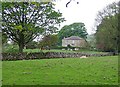
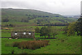
Carr End Farm
In Raydale, near Semer Water.
Image: © James Allan
Taken: 12 Feb 2013
0.01 miles
3
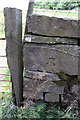
Benchmark on wall at gateway, Carr End Farm
Ordnance Survey cut mark benchmark described on the Bench Mark Database at http://www.bench-marks.org.uk/bm39045
Image: © Roger Templeman
Taken: 9 Aug 2011
0.04 miles
4
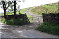
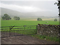
Gateway on Marsett Lane opposite Carr End Farm
There is an OS benchmark Image on a stone at the end of the wall by the right hand side gatepost.
Image: © Roger Templeman
Taken: 9 Aug 2011
0.04 miles
6
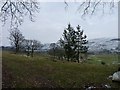
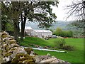
Trees near Carr End farm
Semer Water is just visible in the distance.
Image: © James Allan
Taken: 12 Feb 2013
0.06 miles
8
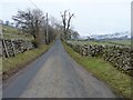
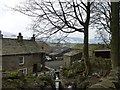
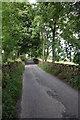
Marsett Lane
Looking towards Carr End Farm.
Image: © James Allan
Taken: 12 Feb 2013
0.11 miles