IMAGES TAKEN NEAR TO
Mill Lane, BEDALE, DL8 2RX
Introduction
This page details the photographs taken nearby to Mill Lane, DL8 2RX by members of the Geograph project.
The Geograph project started in 2005 with the aim of publishing, organising and preserving representative images for every square kilometre of Great Britain, Ireland and the Isle of Man.

There are currently over 7.5m images from over14,400 individuals and you can help contribute to the project by visiting https://www.geograph.org.uk
Image Map
Images are licensed for reuse under creativecommons.org/licenses/by-sa/2.0
Notes
- Clicking on the map will re-center to the selected point.
- The higher the marker number, the further away the image location is from the centre of the postcode.
Image Listing (85 Images Found)
Images are licensed for reuse under creativecommons.org/licenses/by-sa/2.0
Image
Details
Distance
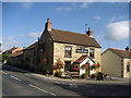
1
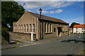
Methodist Chapel
Built in 1849 and near the junction of Bedale Road and Church Street in the village of Well.
Image: © David Rogers
Taken: 21 Jul 2008
0.04 miles
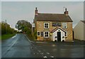
2
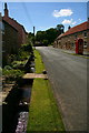
Well Village
Looking up Church Street in the village of Well.
Image: © David Rogers
Taken: 21 Jul 2008
0.05 miles

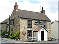
8
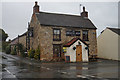
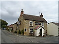
Milbank Arms, Well
The local hostelry for the folk of Well
Image: © Chris Heaton
Taken: 26 Sep 2006
0.08 miles

