IMAGES TAKEN NEAR TO
Thornborough, BEDALE, DL8 2RQ
Introduction
This page details the photographs taken nearby to DL8 2RQ by members of the Geograph project.
The Geograph project started in 2005 with the aim of publishing, organising and preserving representative images for every square kilometre of Great Britain, Ireland and the Isle of Man.

There are currently over 7.5m images from over14,400 individuals and you can help contribute to the project by visiting https://www.geograph.org.uk
Image Map (Loading...)


Getting Data...Please wait
Leaflet Map data © OpenStreetMap
Images are licensed for reuse under creativecommons.org/licenses/by-sa/2.0
Notes
- Clicking on the map will re-center to the selected point.
- The higher the marker number, the further away the image location is from the centre of the postcode.
Image Listing (13 Images Found)
Images are licensed for reuse under creativecommons.org/licenses/by-sa/2.0
Image
Details
Distance
1

Village street, Thornborough
Tiny village with no facilities other than phone and post boxes. Some of the most important prehistoric monuments in Britain are within a mile of the village.
Image: © Gordon Hatton
Taken: 9 May 2010
0.01 miles
2

Thornborough
Small village, very much off the beaten track - noted for the abundance of prehistoric henges close by.
Image: © Chris Heaton
Taken: 16 Aug 2013
0.01 miles
3

Thornborough, Fore Lane
There is a benchmark cut into a roadside stone building on the east side of Fore Lane.
Image: © Mel Towler
Taken: 30 Oct 2021
0.02 miles
4

Thornborough, Fore Lane
There is a benchmark cut into a roadside stone building on the east side of Fore Lane.
Image: © Mel Towler
Taken: 30 Oct 2021
0.02 miles
5

VR Postbox, Thornborough
Box number DL8 153 in the village spelled Thornbrough until the early 1900's.
Image: © David Rogers
Taken: 17 Jan 2010
0.02 miles


8
Back Lane at Thornborough
Looking south-westward. Temporarily closed for three months to vehicular traffic.
Image: © Peter Wood
Taken: 15 Jun 2019
0.18 miles
9

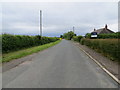
Hedge and tree-lined Fore Lane at Thornborough
Looking north-westward.
Image: © Peter Wood
Taken: 15 Jun 2019
0.18 miles
10
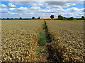
Footpath leading away from Thornborough
The area between the A1, A61 and the River Ure has very few public footpaths and bridleways - this is one of them, so I am glad to see the farmer responsible for this field of wheat has left provision for pedestrians.
Image: © Chris Heaton
Taken: 16 Aug 2013
0.22 miles