IMAGES TAKEN NEAR TO
Carthorpe Road, BEDALE, DL8 2LT
Introduction
This page details the photographs taken nearby to Carthorpe Road, DL8 2LT by members of the Geograph project.
The Geograph project started in 2005 with the aim of publishing, organising and preserving representative images for every square kilometre of Great Britain, Ireland and the Isle of Man.

There are currently over 7.5m images from over14,400 individuals and you can help contribute to the project by visiting https://www.geograph.org.uk
Image Map
Images are licensed for reuse under creativecommons.org/licenses/by-sa/2.0
Notes
- Clicking on the map will re-center to the selected point.
- The higher the marker number, the further away the image location is from the centre of the postcode.
Image Listing (36 Images Found)
Images are licensed for reuse under creativecommons.org/licenses/by-sa/2.0
Image
Details
Distance
1
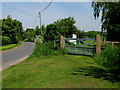
In Memory Of John Craddock
Gate to the Cricket Ground at Kirklington.
Image: © David Rogers
Taken: 25 May 2009
0.04 miles
2
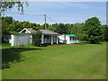
Kirklington Cricket Ground
On the northern edge of the village.
Image: © David Rogers
Taken: 25 May 2009
0.04 miles
4
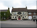
The Black Horse, Kirklington.
Inn at one end of Kirklington village green.
Image: © Gordon Hatton
Taken: 7 Jun 2007
0.08 miles
6
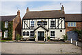
Kirklington Village
From right to left; Tattersalls, The Black Horse Inn and The Old Forge.
Image: © David Rogers
Taken: 25 May 2009
0.08 miles
8
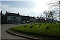
Daffodils on the green
Looking across part of the village of Kirklington.
Image: © DS Pugh
Taken: 31 Mar 2021
0.09 miles
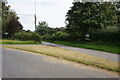
9
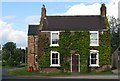
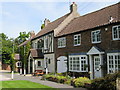
Kirklington Forge
The old Forge at the northern edge of the village green.
Image: © David Rogers
Taken: 26 May 2009
0.09 miles