IMAGES TAKEN NEAR TO
Kirklington, BEDALE, DL8 2LS
Introduction
This page details the photographs taken nearby to DL8 2LS by members of the Geograph project.
The Geograph project started in 2005 with the aim of publishing, organising and preserving representative images for every square kilometre of Great Britain, Ireland and the Isle of Man.

There are currently over 7.5m images from over14,400 individuals and you can help contribute to the project by visiting https://www.geograph.org.uk
Image Map (Loading...)


Getting Data...Please wait
Leaflet Map data © OpenStreetMap
Images are licensed for reuse under creativecommons.org/licenses/by-sa/2.0
Notes
- Clicking on the map will re-center to the selected point.
- The higher the marker number, the further away the image location is from the centre of the postcode.
Image Listing (13 Images Found)
Images are licensed for reuse under creativecommons.org/licenses/by-sa/2.0
Image
Details
Distance
1

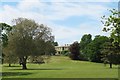
Camp Hill
A grand early Victorian house in large grounds occupied by a company offering, amongst other things, corporate team building and an Aerial Extreme Ropes Course see http://www.aerialextreme.co.uk/index.php/about
Image: © Mick Garratt
Taken: 18 Oct 2008
0.02 miles
2
Camp Hill
Early 19thC grade two listed house set in extensive park land and now the centre for various outdoor activities and corporate events.
Image: © Gordon Hatton
Taken: 23 May 2020
0.03 miles
3
Camp Hill Estate
Adventure and corporate pursuits venue offering amongst other activities, archery, quad bikes, laser combat, forest and canopy experience.
Image: © David Rogers
Taken: 26 May 2009
0.10 miles
4

The Orangery, Camp Hill
Part of a grand early Victorian house in large grounds occupied by a company offering, amongst other things, corporate team building and an Aerial Extreme Ropes Course see http://www.aerialextreme.co.uk/index.php/about
Image: © Mick Garratt
Taken: 18 Oct 2008
0.12 miles
5
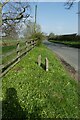
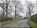
Grass verge near Camp Hill
Looking along the road leading north from Kirklington.
Image: © DS Pugh
Taken: 31 Mar 2021
0.17 miles
6
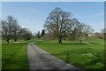
Driveway to Camp Hill
Looking along the track in the grounds of Camp Hill.
Image: © DS Pugh
Taken: 31 Mar 2021
0.18 miles
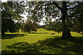
7
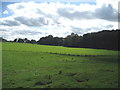
Fields falling away to Camp Hill
The boundary of Camp Hill is marked by the line of trees to the south. It is not a hill. A stately home now given over to team building exercises for high flying executives
Image: © Chris Heaton
Taken: 26 Sep 2006
0.20 miles
8
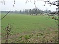
Large arable field alongside drive
Seen through a gap in a gappy hedge.
Image: © Christine Johnstone
Taken: 15 Mar 2011
0.20 miles
9
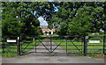
Road to Carthorpe
On the left is the entrance to 'Aerial Extreme' at Camp Hill.
Image: © Christine Johnstone
Taken: 15 Mar 2011
0.21 miles
10
Badger Farm.
Known as Carthorpe Lodge in the 1850's, and East Lodge on current maps.
Image: © David Rogers
Taken: 26 May 2009
0.23 miles