IMAGES TAKEN NEAR TO
South End Terrace, BEDALE, DL8 2DJ
Introduction
This page details the photographs taken nearby to South End Terrace, DL8 2DJ by members of the Geograph project.
The Geograph project started in 2005 with the aim of publishing, organising and preserving representative images for every square kilometre of Great Britain, Ireland and the Isle of Man.

There are currently over 7.5m images from over14,400 individuals and you can help contribute to the project by visiting https://www.geograph.org.uk
Image Map
Images are licensed for reuse under creativecommons.org/licenses/by-sa/2.0
Notes
- Clicking on the map will re-center to the selected point.
- The higher the marker number, the further away the image location is from the centre of the postcode.
Image Listing (93 Images Found)
Images are licensed for reuse under creativecommons.org/licenses/by-sa/2.0
Image
Details
Distance
3

Bedale, Mowbray Grange
The weathered benchmark is cut into the north-east face of Mowbray Grange. The hospital has been converted to private flats.
Image: © Mel Towler
Taken: 16 Jul 2022
0.05 miles
4
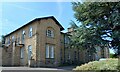
Bedale, Mowbray Grange
There is a weathered benchmark cut into the north-east face of Mowbray Grange. The hospital has been converted to private flats.
Image: © Mel Towler
Taken: 16 Jul 2022
0.06 miles
5
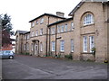
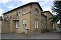
Bedale old workhouse
The former workhouse or union house in South End, Bedale. The Bedale Poor Law Union was created in March 1839 and the workhouse erected shortly after. It was built for around 100 inmates and continued as a workhouse until 1924.
In the thirties it became a TB sanatorium, later changing to Mowbray Grange Hospital. After the hospital closed it was converted for residential use in the 1990's.
Image: © Gordon Hatton
Taken: 28 Oct 2009
0.06 miles
6
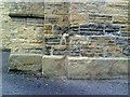
Benchmark on former hospital at Mowbray Grange
Ordnance Survey cut mark benchmark which is described on the Bench Mark Database at http://www.bench-marks.org.uk/bm34933
Image: © Roger Templeman
Taken: 22 Jul 2010
0.06 miles
7
Former Grange Hospital, South End
There is an OS benchmark Image on the near angle of the jut on the front face
Image: © Roger Templeman
Taken: 16 Jun 2013
0.06 miles
8
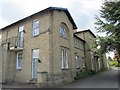
Mowbray Grange, South End #1
Mowbray Grange was built in 1839 as a Poor Law workhouse and later used as a geriatric hospital. It is now an apartment block. The building is grade II listed.
LBS No: 333558
Image: © Mike Kirby
Taken: 14 May 2014
0.06 miles
9
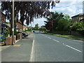
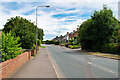
South End (B6285), Bedale
Looking south east.
Image: © JThomas
Taken: 1 Jun 2017
0.06 miles