IMAGES TAKEN NEAR TO
Newton Le Willows, BEDALE, DL8 1TG
Introduction
This page details the photographs taken nearby to DL8 1TG by members of the Geograph project.
The Geograph project started in 2005 with the aim of publishing, organising and preserving representative images for every square kilometre of Great Britain, Ireland and the Isle of Man.

There are currently over 7.5m images from over14,400 individuals and you can help contribute to the project by visiting https://www.geograph.org.uk
Image Map
Images are licensed for reuse under creativecommons.org/licenses/by-sa/2.0
Notes
- Clicking on the map will re-center to the selected point.
- The higher the marker number, the further away the image location is from the centre of the postcode.
Image Listing (6 Images Found)
Images are licensed for reuse under creativecommons.org/licenses/by-sa/2.0
Image
Details
Distance
2
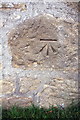
Benchmark on Woodbine House annex
Ordnance Survey cut mark benchmark described on the Bench Mark Database at http://www.bench-marks.org.uk/bm60843
Image: © Roger Templeman
Taken: 21 Sep 2014
0.05 miles
3
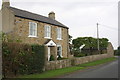
The annex at 'Woodbine House'
There is an OS benchmark Image on the near corner of the building on the left hand face
Image: © Roger Templeman
Taken: 21 Sep 2014
0.05 miles
4
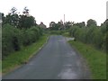
Lane at Newton le Willows
The lane leading south westwards out of the village towards Cocked Hat. Woodbine House in the distance.
Image: © Gordon Hatton
Taken: 4 Sep 2011
0.08 miles
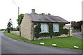
5
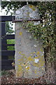
Benchmark on gatepost at entrance to Ruswick Manor
Ordnance Survey cut mark benchmark described on the Bench Mark Database at http://www.bench-marks.org.uk/bm60844
Image: © Roger Templeman
Taken: 21 Sep 2014
0.21 miles
6
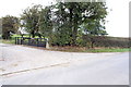
Entrance track to Ruswick Manor
There is an OS benchmark Image on the stone gatepost
Image: © Roger Templeman
Taken: 21 Sep 2014
0.21 miles