IMAGES TAKEN NEAR TO
School Lane, BEDALE, DL8 1SH
Introduction
This page details the photographs taken nearby to School Lane, DL8 1SH by members of the Geograph project.
The Geograph project started in 2005 with the aim of publishing, organising and preserving representative images for every square kilometre of Great Britain, Ireland and the Isle of Man.

There are currently over 7.5m images from over14,400 individuals and you can help contribute to the project by visiting https://www.geograph.org.uk
Image Map
Images are licensed for reuse under creativecommons.org/licenses/by-sa/2.0
Notes
- Clicking on the map will re-center to the selected point.
- The higher the marker number, the further away the image location is from the centre of the postcode.
Image Listing (23 Images Found)
Images are licensed for reuse under creativecommons.org/licenses/by-sa/2.0
Image
Details
Distance
1
Bus stop and departing bus, Newton-le-Willows
As the tracks show, the Bedale bus comes down from the A684 and turns round here.
Image: © Christine Johnstone
Taken: 1 Mar 2011
0.05 miles
2
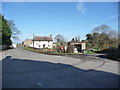
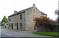
Imposing building, Newton-le-Willows
Originally built as The Wheat Sheaf Public House. Now a private dwelling.
Image: © Christine Johnstone
Taken: 1 Mar 2011
0.06 miles
3
No pints available here
On the right is the closed and decaying former Wheatsheaf public house, which is perhaps the most curious building in Newton le Willows. In terms of scale, design and materials it is quite out of place here. Perhaps the best plan would be to demolish it.
Image: © Gordon Hatton
Taken: 4 Sep 2011
0.07 miles
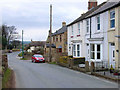
4
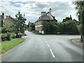
Newton le Willows
Approaching the junction with Station Road on the right from Brompton Road.
Image: © David Robinson
Taken: 21 Jul 2019
0.07 miles
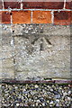
5
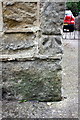
Benchmark on #1 Brompton Road
Ordnance Survey cut mark benchmark described on the Bench Mark Database at http://www.bench-marks.org.uk/bm34913
Image: © Roger Templeman
Taken: 21 Sep 2014
0.08 miles
6
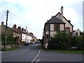
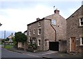
Houses at the south end of Brompton Road
There is an OS benchmark Image on the near corner on the road face of the near house
Image: © Roger Templeman
Taken: 21 Sep 2014
0.08 miles
7
Station Road, Newton-le-Willows
The station has long gone, but the Wensleydale Railway still uses the line.
Image: © Christine Johnstone
Taken: 1 Mar 2011
0.08 miles
8
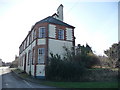
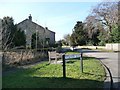
Village houses, Newton le Willows
Traditional houses in the village with stone construction and slate roofs.
Image: © Gordon Hatton
Taken: 4 Sep 2011
0.09 miles
9
Newton-le-Willows, North Yorks
Not to be confused with the other (much larger) Newton-le-Willows near Warrington
Image: © Oliver Dixon
Taken: 18 Mar 2006
0.11 miles
10
Benchmark on former Methodist Chapel
Ordnance Survey pivot benchmark described on the Bench Mark Database at http://www.bench-marks.org.uk/bm60445
Image: © Roger Templeman
Taken: 21 Sep 2014
0.12 miles