IMAGES TAKEN NEAR TO
Newton Le Willows, BEDALE, DL8 1RY
Introduction
This page details the photographs taken nearby to DL8 1RY by members of the Geograph project.
The Geograph project started in 2005 with the aim of publishing, organising and preserving representative images for every square kilometre of Great Britain, Ireland and the Isle of Man.

There are currently over 7.5m images from over14,400 individuals and you can help contribute to the project by visiting https://www.geograph.org.uk
Image Map
Images are licensed for reuse under creativecommons.org/licenses/by-sa/2.0
Notes
- Clicking on the map will re-center to the selected point.
- The higher the marker number, the further away the image location is from the centre of the postcode.
Image Listing (6 Images Found)
Images are licensed for reuse under creativecommons.org/licenses/by-sa/2.0
Image
Details
Distance
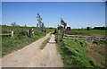
2
Farm Track Crossing The Railway
One of many local crossing points on the Wensleydale Railway.
Image: © Mary and Angus Hogg
Taken: 16 Oct 2018
0.08 miles
4
Grange farm Crossing
There are a number of these farm crossings along the Wensleydale Railway in these parts.
Image: © roger geach
Taken: 1 May 2011
0.16 miles
5
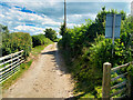
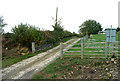
Farm Access Track, Newton Grange Farm
The track from Sinks Lane to Newton Grange Farm crosses the Wensleydale Railway.
Image: © David Dixon
Taken: 5 Jul 2022
0.17 miles