IMAGES TAKEN NEAR TO
Burrill, BEDALE, DL8 1RQ
Introduction
This page details the photographs taken nearby to DL8 1RQ by members of the Geograph project.
The Geograph project started in 2005 with the aim of publishing, organising and preserving representative images for every square kilometre of Great Britain, Ireland and the Isle of Man.

There are currently over 7.5m images from over14,400 individuals and you can help contribute to the project by visiting https://www.geograph.org.uk
Image Map (31 Images)


Getting Data...Please wait
Leaflet Map data © OpenStreetMap
Images are licensed for reuse under creativecommons.org/licenses/by-sa/2.0
Notes
- Clicking on the map will re-center to the selected point.
- The higher the marker number, the further away the image location is from the centre of the postcode.
Image Listing (31 Images Found)
Images are licensed for reuse under creativecommons.org/licenses/by-sa/2.0
Image
Details
Distance
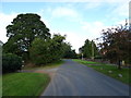
3
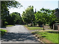
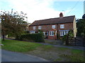
Village street, Burrill
Small one street village which forms its own mini 'conurbation' with neighbouring Cowling.
Image: © Gordon Hatton
Taken: 30 May 2020
0.02 miles
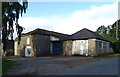
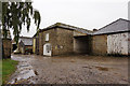
8
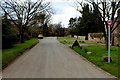
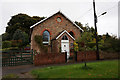
Burrill
Small village in country to the west of Bedale
Image: © Chris Heaton
Taken: 21 Mar 2016
0.04 miles