IMAGES TAKEN NEAR TO
Little Crakehall, BEDALE, DL8 1LD
Introduction
This page details the photographs taken nearby to DL8 1LD by members of the Geograph project.
The Geograph project started in 2005 with the aim of publishing, organising and preserving representative images for every square kilometre of Great Britain, Ireland and the Isle of Man.

There are currently over 7.5m images from over14,400 individuals and you can help contribute to the project by visiting https://www.geograph.org.uk
Image Map
Images are licensed for reuse under creativecommons.org/licenses/by-sa/2.0
Notes
- Clicking on the map will re-center to the selected point.
- The higher the marker number, the further away the image location is from the centre of the postcode.
Image Listing (7 Images Found)
Images are licensed for reuse under creativecommons.org/licenses/by-sa/2.0
Image
Details
Distance
3
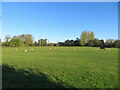
Grazing pasture being used by sheep and a horse
Looking northward from the Crakehall to Kirkbridge road.
Image: © Peter Wood
Taken: 4 Nov 2022
0.23 miles
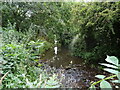
4
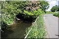
Bedale Beck beside minor road
There is an OS benchmark Image on the top of the end fence post. The junction just visible is to a waste water works
Image: © Roger Templeman
Taken: 29 May 2012
0.23 miles
5
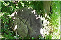
Benchmark on post beside Bedale Beck
Ordnance Survey cut mark benchmark described on the Bench Mark Database at http://www.bench-marks.org.uk/bm43225
Image: © Roger Templeman
Taken: 29 May 2012
0.24 miles