IMAGES TAKEN NEAR TO
Patrick Brompton, BEDALE, DL8 1JY
Introduction
This page details the photographs taken nearby to DL8 1JY by members of the Geograph project.
The Geograph project started in 2005 with the aim of publishing, organising and preserving representative images for every square kilometre of Great Britain, Ireland and the Isle of Man.

There are currently over 7.5m images from over14,400 individuals and you can help contribute to the project by visiting https://www.geograph.org.uk
Image Map (Loading...)


Getting Data...Please wait
Leaflet Map data © OpenStreetMap
Images are licensed for reuse under creativecommons.org/licenses/by-sa/2.0
Notes
- Clicking on the map will re-center to the selected point.
- The higher the marker number, the further away the image location is from the centre of the postcode.
Image Listing (4 Images Found)
Images are licensed for reuse under creativecommons.org/licenses/by-sa/2.0
Image
Details
Distance
2
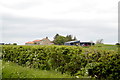
Benchmark on barn at East Farm
Ordnance Survey cut mark benchmark described on the Bench Mark Database at http://www.bench-marks.org.uk/bm51048
Image: © Roger Templeman
Taken: 26 Aug 2013
0.02 miles
3
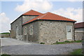
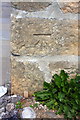
Buildings at East Farm
There is an OS benchmark Image on the second quoin above ground on the front left corner
Image: © Roger Templeman
Taken: 26 Aug 2013
0.02 miles
4
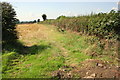
Stubble field south of East Farm
There is a gatepost hidden in the hedge, but no sign of a wall carrying an Ordnance Survey benchmark which was verified in 1955
Image: © Roger Templeman
Taken: 26 Aug 2013
0.14 miles