IMAGES TAKEN NEAR TO
East View, BEDALE, DL8 1JS
Introduction
This page details the photographs taken nearby to East View, DL8 1JS by members of the Geograph project.
The Geograph project started in 2005 with the aim of publishing, organising and preserving representative images for every square kilometre of Great Britain, Ireland and the Isle of Man.

There are currently over 7.5m images from over14,400 individuals and you can help contribute to the project by visiting https://www.geograph.org.uk
Image Map
Images are licensed for reuse under creativecommons.org/licenses/by-sa/2.0
Notes
- Clicking on the map will re-center to the selected point.
- The higher the marker number, the further away the image location is from the centre of the postcode.
Image Listing (39 Images Found)
Images are licensed for reuse under creativecommons.org/licenses/by-sa/2.0
Image
Details
Distance
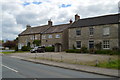
1
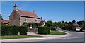
House on the corner
Village house in Patrick Brompton. The village is on the boundary between stone and brick, slate and tiles, so houses here tend to be built of a variety of traditional materials.
Image: © Gordon Hatton
Taken: 16 Jun 2010
0.03 miles
4
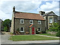
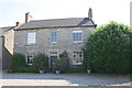
Ashla House and Laurel House
Nice contrast in building style and materials in Patrick Brompton.
Image: © Tony Simms
Taken: 20 May 2015
0.05 miles
5
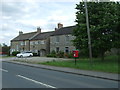
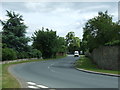
Houses on the A684, Patrick Brompton
Showing position of Postbox No. DL8 69.
See Image] for postbox.
Image: © JThomas
Taken: 1 Jun 2017
0.05 miles
6
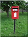
Elizabeth II postbox on the A684, Patrick Brompton
Postbox No. DL8 69.
See Image] for context.
Image: © JThomas
Taken: 1 Jun 2017
0.06 miles
7
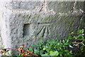
Benchmark on 'Laurel House'
Ordnance Survey cut mark benchmark described on the Bench Mark Database at http://www.bench-marks.org.uk/bm51047
Image: © Roger Templeman
Taken: 26 Aug 2013
0.06 miles
8
Laurel House
There is an OS benchmark Image on the front left corner of the house behind the shrub
Image: © Roger Templeman
Taken: 26 Aug 2013
0.06 miles
9

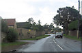
Patrick Brompton
Typical Wensleydale village.The original settlement of Patrick Brompton was founded, and named after, the parish church of Saint Patrick, which dates back to the times of the Norman Conquest and still stands on the western edge of the village. There are two village greens, one ancient, one modern, and a local pub built in the 17th century, originally as a vicarage for the local priest.
Image: © Lynne Kirton
Taken: 30 Jun 2006
0.07 miles