IMAGES TAKEN NEAR TO
Crakehall, BEDALE, DL8 1HG
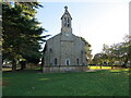
Introduction
This page details the photographs taken nearby to DL8 1HG by members of the Geograph project.
The Geograph project started in 2005 with the aim of publishing, organising and preserving representative images for every square kilometre of Great Britain, Ireland and the Isle of Man.

There are currently over 7.5m images from over14,400 individuals and you can help contribute to the project by visiting https://www.geograph.org.uk
Image Map
Images are licensed for reuse under creativecommons.org/licenses/by-sa/2.0
Notes
- Clicking on the map will re-center to the selected point.
- The higher the marker number, the further away the image location is from the centre of the postcode.
Image Listing (80 Images Found)
Images are licensed for reuse under creativecommons.org/licenses/by-sa/2.0
Image
Details
Distance
1
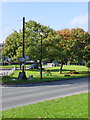
Village green, Crakehall
Looking across the A684 to another area of the village green.
Image: © Maigheach-gheal
Taken: 4 Oct 2010
0.03 miles
2
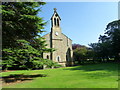
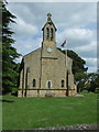
St Gregory's Church, Crakehall
The church was built in 1840 and it was designed by John Harper. The church stands on a large green.
Image: © Maigheach-gheal
Taken: 4 Oct 2010
0.03 miles
3
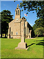
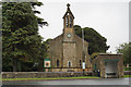
War Memorial and the Church of St Gregory, Great Crakehall
The Crakehall War Memorial stands on the village green outside the parish church. It is in the form of a floriated Celtic-style wheel cross with a decorated stem. The cross has a central rose with leaves on the arms whilst the stem is decorated with base relief panels of flowers, shields, and masonic dividers. The dedication is inscribed at the bottom of the shaft; it reads: "IN PROUD AND LOVING MEMORY OF THE MEN FROM THIS PARISH WHO GAVE THEIR LIVES FOR FREEDOM'S CAUSE IN THE GREAT WAR 1914 - 1918."
The base has a list of the twelve men who lost their lives in the First World War. Below this is a further inscription:
"SONS OF THIS PLACE LET THIS OF YOU BE SAID
THAT YOU WHO LIVE ARE WORTHY OF THE DEAD.
THEY GAVE THEIR LIVES THAT YOU WHO LIVE MAY REAP
A RICHER HARVEST ERE YOU FALL ASLEEP."
The memorial is sited in front of the Parish Church of St Gregory which was erected in 1840. The war memorial and the church are both Grade II-listed:
War Memorial List entry 1390922 https://historicengland.org.uk/listing/the-list/list-entry/1390922
Church List Entry 1174356 https://historicengland.org.uk/listing/the-list/list-entry/1174356
Image: © David Dixon
Taken: 7 Jul 2021
0.03 miles
4
St Gregory parish church Gt Crakehall
Built in 1840 by John Slater
Image: © Martin Dawes
Taken: 1 Jun 2018
0.03 miles
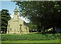
7
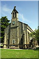
St Gregory's Church
There is an OS benchmark Image on the front left corner of the jut which has the bells at its top
Image: © Roger Templeman
Taken: 29 May 2012
0.03 miles
8
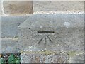
Ordnance Survey Cut Mark
This mark can be found on the wall of St Gregory's Church, Crakehall.
The recorded details give a height of 54.3489 metres above sea level.
For more detail see : https://www.bench-marks.org.uk/bm30615
Image: © Peter Wood
Taken: 4 Nov 2022
0.03 miles
9
The Church of St Vincent, Crakehall
Viewed from the west.
Image: © Peter Wood
Taken: 4 Nov 2022
0.03 miles
10
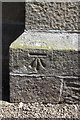
Benchmark on St Gregory's Church
Ordnance Survey cut mark benchmark described on the Bench Mark Database at http://www.bench-marks.org.uk/bm30615
Image: © Roger Templeman
Taken: 29 May 2012
0.04 miles