IMAGES TAKEN NEAR TO
Low Street, NORTHALLERTON, DL7 9LT
Introduction
This page details the photographs taken nearby to Low Street, DL7 9LT by members of the Geograph project.
The Geograph project started in 2005 with the aim of publishing, organising and preserving representative images for every square kilometre of Great Britain, Ireland and the Isle of Man.

There are currently over 7.5m images from over14,400 individuals and you can help contribute to the project by visiting https://www.geograph.org.uk
Image Map
Images are licensed for reuse under creativecommons.org/licenses/by-sa/2.0
Notes
- Clicking on the map will re-center to the selected point.
- The higher the marker number, the further away the image location is from the centre of the postcode.
Image Listing (7 Images Found)
Images are licensed for reuse under creativecommons.org/licenses/by-sa/2.0
Image
Details
Distance
1
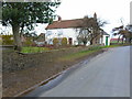
Warren House, near Little Fencote
Farm on the west side of Low Street.
Image: © Christine Johnstone
Taken: 23 Mar 2018
0.00 miles
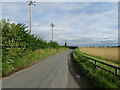
2
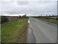
Low Street heading north to a 42 metre spot height
Part of the national cycle network - route 71.
Image: © Christine Johnstone
Taken: 23 Mar 2018
0.15 miles
3
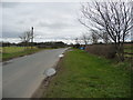
Low Street, heading south to Leeming Bar
Part of the national cycle network - route 71.
Image: © Christine Johnstone
Taken: 23 Mar 2018
0.15 miles
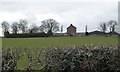
4
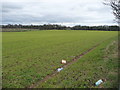
Litter on farmland near Warren House
Perhaps blown out of a recycling box.
Image: © Christine Johnstone
Taken: 23 Mar 2018
0.16 miles
5
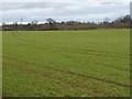
Farmland and trees, south of Little Fencote
The hedged field boundary is also a civil parish boundary. Aiskew this side [south], Kirkby Fleetham with Fencote beyond [north].
Image: © Christine Johnstone
Taken: 23 Mar 2018
0.21 miles
6
National Cycle Route 71
Low Street towards Little Fencote.
Image: © JThomas
Taken: 24 Jul 2020
0.25 miles