IMAGES TAKEN NEAR TO
Northallerton Road, NORTHALLERTON, DL7 9LQ
Introduction
This page details the photographs taken nearby to Northallerton Road, DL7 9LQ by members of the Geograph project.
The Geograph project started in 2005 with the aim of publishing, organising and preserving representative images for every square kilometre of Great Britain, Ireland and the Isle of Man.

There are currently over 7.5m images from over14,400 individuals and you can help contribute to the project by visiting https://www.geograph.org.uk
Image Map
Images are licensed for reuse under creativecommons.org/licenses/by-sa/2.0
Notes
- Clicking on the map will re-center to the selected point.
- The higher the marker number, the further away the image location is from the centre of the postcode.
Image Listing (18 Images Found)
Images are licensed for reuse under creativecommons.org/licenses/by-sa/2.0
Image
Details
Distance
2
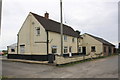
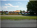
Vickers, Northallerton Road, Leeming Bar
Motor repairers and 4x4 specialist.
Image: © Stephen Craven
Taken: 14 Jul 2018
0.02 miles
3
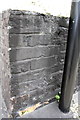
Benchmark on Blow House Farm
The Ordnance Survey cut mark benchmark, partly hidden behind the black downpipe, is described on the Bench Mark Database at http://www.bench-marks.org.uk/bm51299
Image: © Roger Templeman
Taken: 1 Sep 2013
0.03 miles
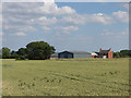
4
Blow House Farm
There is an OS benchmark Image behind the black downpipe behind the black wheelie bin
Image: © Roger Templeman
Taken: 1 Sep 2013
0.03 miles
5
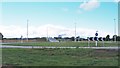
New roundabout on A684
The eastern end of the new [August 2016] Bedale and Leeming Bar by pass which takes the A684 Northallerton to Leyburn road past the two places named above. The new road also provides a link to the recently upgraded A1[M] at junction 51.
Image: © Gordon Hatton
Taken: 22 Aug 2016
0.08 miles
7
Old and new - the A684 east of Leeming
Image: © Oliver Dixon
Taken: 18 Mar 2006
0.16 miles
8
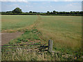
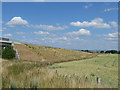
Unsurfaced track across a field
It seems that at one time this track would have had a level crossing over the railway, which is now disused. It also forms the parish boundary between Scruton (left) and Aiskew (right), which suggests that there would also have been a field boundary here at one time.
Image: © Stephen Craven
Taken: 14 Jul 2018
0.17 miles
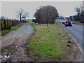
10
Bedale bypass bridge over Wensleydale Railway (1)
Until this bypass was opened in August 2016, traffic on the main A684 road through Bedale had to wait at the level crossing Image on the (admittedly few) occasions that a train came through. This is the western embankment of the southern approach, planted with trees that will obscure the road within a few decades.
Image: © Stephen Craven
Taken: 14 Jul 2018
0.18 miles