IMAGES TAKEN NEAR TO
North Otterington, NORTHALLERTON, DL7 9JG
Introduction
This page details the photographs taken nearby to DL7 9JG by members of the Geograph project.
The Geograph project started in 2005 with the aim of publishing, organising and preserving representative images for every square kilometre of Great Britain, Ireland and the Isle of Man.

There are currently over 7.5m images from over14,400 individuals and you can help contribute to the project by visiting https://www.geograph.org.uk
Image Map
Images are licensed for reuse under creativecommons.org/licenses/by-sa/2.0
Notes
- Clicking on the map will re-center to the selected point.
- The higher the marker number, the further away the image location is from the centre of the postcode.
Image Listing (24 Images Found)
Images are licensed for reuse under creativecommons.org/licenses/by-sa/2.0
Image
Details
Distance
1
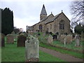
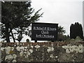
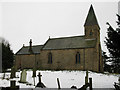
St Michael and All Angels Church, North Otterington
Image: © JThomas
Taken: 2 Dec 2011
0.09 miles
2
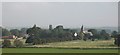
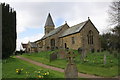
North Otterington
Seen from across the fields, North Otterington is a decayed village, nowadays comprising a small church, farms and a very few houses.
Image: © Gordon Hatton
Taken: 25 Sep 2008
0.09 miles
3
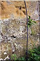
Weathered benchmark on St Michael & All Angels
Ordnance Survey 1GL bolt benchmark described on the Bench Mark Database at http://www.bench-marks.org.uk/bm30614
Image: © Roger Templeman
Taken: 5 May 2013
0.09 miles
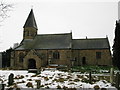
4
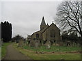
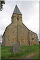
St Michael and All Angels' Church
A dismal February day which makes the rather old graveyard look uninviting
Image: © Martin Dawes
Taken: 20 Feb 2012
0.09 miles
6
St Michael & All Angels
The church spire is an Ordnance Survey intersected station trig point, http://www.trigpointinguk.com/trigs/trig-details.php?t=10998
Image: © Roger Templeman
Taken: 5 May 2013
0.10 miles
7
Southwest face and spire of St Michael & All Angels
There is an OS benchmark Image to the left of the gravestone in the foreground. The spire is an OS intersected station trig point, http://www.trigpointinguk.com/trigs/trig-details.php?t=10998
Image: © Roger Templeman
Taken: 5 May 2013
0.10 miles
8
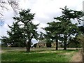
St. Michael and All Angels' Church, North Otterington
A somewhat isolated church with no "village" of North Otterington. Perhaps it did exist at some time.
Image: © Mick Garratt
Taken: 14 Apr 2006
0.10 miles
9
St Michael & All Angels, North Otterington
In the year 1890 the church was described as "a plain ancient structure, erected, it is supposed, in the latter half of the 12th century". The tower was built or rebuilt in 1805, and the spire added in 1865.
Image: © David Rogers
Taken: 11 Jan 2010
0.10 miles
10
St Michael & All Saints, North Otterington
The church has undergone several restorations since its erection in the late Norman period.
Image: © David Rogers
Taken: 11 Jan 2010
0.10 miles