IMAGES TAKEN NEAR TO
Boroughbridge Road, NORTHALLERTON, DL7 9EP
Introduction
This page details the photographs taken nearby to Boroughbridge Road, DL7 9EP by members of the Geograph project.
The Geograph project started in 2005 with the aim of publishing, organising and preserving representative images for every square kilometre of Great Britain, Ireland and the Isle of Man.

There are currently over 7.5m images from over14,400 individuals and you can help contribute to the project by visiting https://www.geograph.org.uk
Image Map
Images are licensed for reuse under creativecommons.org/licenses/by-sa/2.0
Notes
- Clicking on the map will re-center to the selected point.
- The higher the marker number, the further away the image location is from the centre of the postcode.
Image Listing (16 Images Found)
Images are licensed for reuse under creativecommons.org/licenses/by-sa/2.0
Image
Details
Distance
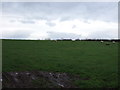
1
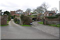
Otterington House
View from track to Stubb House
Image: © Roger Templeman
Taken: 5 May 2013
0.01 miles
2
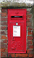
GR Postbox, North Otterington
Box number DL7 21 beside the A167 Boroughbridge Road.
Image: © David Rogers
Taken: 11 Jan 2010
0.01 miles
4
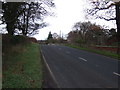
A167 passing Mulberry Cottage 219 miles from London
The milestone Image in the verge also gives Northallerton 2 , Boroughbridge 17
Image: © Luke Shaw
Taken: 26 Sep 2021
0.04 miles
6
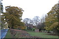
North Otterington House peeking out from behind the trees
Difficult to get a good proper view of the hall...
Image: © Nick W
Taken: 8 Nov 2008
0.06 miles
7
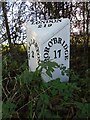
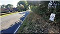
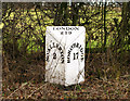
Old milepost
Surveyed by the Milestone Society. One of several mileposts of this design still in situ on the Yorkshire section of the 35 miles between Boroughbridge and Darlington. This is opposite Mulberry Cottage near Otterington House and is well cared for.
Image: © Chris Minto
Taken: 22 Nov 2020
0.07 miles
8
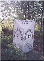
Old Milestone, on the A167, Mulberry Cottage
Near Otterington House. Located on the West side of road. Cast iron post, Northallerton casting design, 19th century. Alternative views see http://www.geograph.org.uk/photo/3468906 & http://www.geograph.org.uk/photo/151937 & http://www.geograph.org.uk/photo/1749355 & http://www.geograph.org.uk/photo/6687080
Inscription reads: NO'ALLERTON / 2 // BORO'BRIDGE / 17 // LONDON / 219
Milestone Society National ID: YN_NABB02
Image: © Christine Minto
Taken: 21 Dec 2005
0.07 miles
9
Otterington Milepost
Beside the A167 Boroughbridge Road.
Image: © David Rogers
Taken: 12 Mar 2010
0.08 miles
10
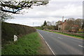
The A167 Boroughbridge Road south of Avenue Farm
The milepost on the left of the image can be seen in detail at Image Avenue farm is in the background on the right hand side of the road
Image: © Roger Templeman
Taken: 5 May 2013
0.09 miles