IMAGES TAKEN NEAR TO
Northallerton Road, NORTHALLERTON, DL7 9AL
Introduction
This page details the photographs taken nearby to Northallerton Road, DL7 9AL by members of the Geograph project.
The Geograph project started in 2005 with the aim of publishing, organising and preserving representative images for every square kilometre of Great Britain, Ireland and the Isle of Man.

There are currently over 7.5m images from over14,400 individuals and you can help contribute to the project by visiting https://www.geograph.org.uk
Image Map
Images are licensed for reuse under creativecommons.org/licenses/by-sa/2.0
Notes
- Clicking on the map will re-center to the selected point.
- The higher the marker number, the further away the image location is from the centre of the postcode.
Image Listing (12 Images Found)
Images are licensed for reuse under creativecommons.org/licenses/by-sa/2.0
Image
Details
Distance
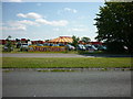
2
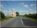
#43 Northallerton Road
Northallerton Road is the A684 and the building is a North Yorkshire County Council depot
Thanks to Matthew Hatton the following information:
This is Blow Houses Brick & Tile Works, the building was the office and the now flat yard behind had various sizes of clay pits, a pump to clear away the water and workers sheds. I think it is possible there would have been a firing kiln too but this is not marked on the 1892 map.
It is shown as "old claypits" on the 1919 OS Map. However Brick and Tile works were moved to a new site at Terry House, less than half a mile to the south
Image: © Roger Templeman
Taken: 1 Sep 2013
0.01 miles
3
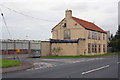
Council depot, Leeming Bar
Built on the site of an infilled clay pit, as explained here: Image
Image: © Stephen Craven
Taken: 14 Jul 2018
0.01 miles
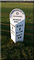
4
Milepost on NW side of Northallerton Road SW of North Yorkshire Highways depot
The milepost has Milestone Society National ID: NY_NALB06
Image: © Roger Templeman
Taken: 7 Jul 2024
0.02 miles
5
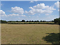
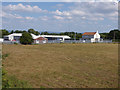
Field with sheep outside Leeming Bar
Image: © Stephen Craven
Taken: 14 Jul 2018
0.06 miles
6
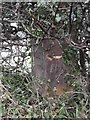
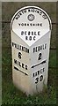
Old Milepost by Northallerton Road, Leeming Bar
Cast iron post by the UC road (former A684), in parish of EXELBY LEEMING AND NEWTON (HAMBLETON District), Northallerton Road, Leeming Bar, under hedge, just west of factory/depot, on North side of road. Bedale rose iron casting, erected by the District Council in the 20th century.
Inscription reads:-
: NoALLERTON / 6 / MILES / {arrow->} : : NORTH RIDING OF / {rose} / YORKSHIRE / BEDALE / RDC : : BEDALE / 2 / {<-arrow} / HAWES / 30 :
North Yorkshire HER.
NY SMR Number: MNY36487 https://www.heritagegateway.org.uk/Gateway/Results_Single.aspx?uid=MNY36487&resourceID=1009
Milestone Society National ID: YN_NALB06.
Image: © C Minto
Taken: 30 Dec 2003
0.07 miles
7
North Riding CC Milepost
A milepost cast at the Mattisons of Bedale foundry, late 19C or early 20C for North Riding County Council. On the A684 just east of Leeming Bar. It has been repainted and moved slightly eastwards from under a hedge to open space near the Highways depot.
Image: © Helen Kirk
Taken: 3 Feb 2020
0.08 miles
8
Farm crossing near Leeming Bar
Not a public right of way. This looks to have been a vehicle access track or "accommodation crossing" for a farm, but it looks to be a long time since a vehicle used it.
Image: © Stephen Craven
Taken: 14 Jul 2018
0.12 miles
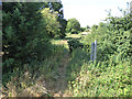
10
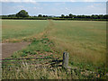
Unsurfaced track across a field
It seems that at one time this track would have had a level crossing over the railway, which is now disused. It also forms the parish boundary between Scruton (left) and Aiskew (right), which suggests that there would also have been a field boundary here at one time.
Image: © Stephen Craven
Taken: 14 Jul 2018
0.14 miles